|
search place name
|
||
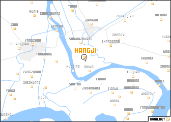
Hangji (Jiangsu, China)Hangji is a town in the Jiangsu region of China. An overview map of the region around Hangji is displayed below.
regional and 3d topo map of Hangji, China ::
Hangji airports ::
The nearest airport is NKG - Nanjing Lukou, located 94.1 km south west of Hangji.
Other airports nearby include SHA - Shanghai Hongqiao Intl (213.7 km south east), Nearby towns ::
Shiwei (2.3km south) //
Huoqiao (3.2km south west) //
Shujiazhuang (4.1km north) //
Lidian (5.7km south east) //
Shujiaqiao (5.3km west) //
Shatou (6.3km south) //
Zhanggang (5.8km north east) //
Jiadangwei (6.9km south) //
Jiangdu (8.1km north) //
Zhengyi (7.9km north east) //
Tianji (8.6km south east) //
Wantou (8.6km north west) //
Shiqiao (9.4km south west) //
Hongqiao (10.1km south east) //
Zhuanqiao (11.5km north east) //
[all distances 'as the bird flies' and approximate]  Places with similar names to Hangji, China ::
// Hongji (KP)
// Hongji (KR)
// Hŭngji (KR)
// Huangjia (CN)
// Huangjia'ao (CN)
// Huangjia'ao (CN)
// Huangjia'ao (CN)
// Hinokage (JP)
// Hengji (CN)
// Hengjia (CN)
Disclaimer :: Information on this page comes without warranty of any kind |
||
|
Where is Hangji? Elevation and coordinates ::
Latitude (lat): 32°21'51"N Longitude (lon): 119°32'23"E
Elevation (approx.): 8m (map arrows pan, magnifying glasses zoom) |
||
|
Visiting Hangji? Hotel/Accommodation ::
Book a hotel in Hangji Travel Guide ::
Buy a travel guide for China rental cars ::
car rental offers GPS waypoint ::
download a GPX waypoint (PoI) of Hangji for your GPS receiver
|
||