|
search place name
|
||
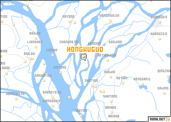
Hongwuguo (Guangdong, China)Hongwuguo is a town in the Guangdong region of China. An overview map of the region around Hongwuguo is displayed below.
regional and 3d topo map of Hongwuguo, China ::
Hongwuguo airports ::
The nearest airport is SZX - Shenzhen Baoan Intl, located 42.8 km south east of Hongwuguo.
Other airports nearby include CAN - Guangzhou Baiyun Intl (55.7 km north west), HKG - Hong Kong Intl (80.3 km south east), MFM - Macau Intl (91.1 km south), Nearby towns ::
Hongmei (3.3km north east) //
Zhangpeng (4.5km north west) //
Hetianjiao (4.5km east) //
Shatian (5.6km south) //
Xinyong (5.5km south west) //
Shatian (6.0km south) //
Houjie (6.2km south east) //
Xinsha (6.8km west) //
Shuanggang (7.3km south east) //
Daojiao (7.0km north east) //
Chongkou (7.6km south east) //
Machong (8.7km north) //
Niweiwei (8.7km south) //
Mayong (9.2km north) //
Hetian (9.0km south east) //
Shatang (10.3km south east) //
Shangyong (10.4km south west) //
[all distances 'as the bird flies' and approximate] 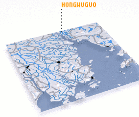 Places with similar names to Hongwuguo, China :: Disclaimer :: Information on this page comes without warranty of any kind |
||
|
Where is Hongwuguo? Elevation and coordinates ::
Latitude (lat): 22°58'20"N Longitude (lon): 113°35'54"E
Elevation (approx.): 5m (map arrows pan, magnifying glasses zoom) |
||
|
Visiting Hongwuguo? Hotel/Accommodation ::
Book a hotel in Hongwuguo Travel Guide ::
Buy a travel guide for China rental cars ::
car rental offers GPS waypoint ::
download a GPX waypoint (PoI) of Hongwuguo for your GPS receiver
|
||