|
search place name
|
||
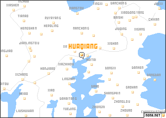
Huaqiang (Zhejiang, China)Huaqiang is a town in the Zhejiang region of China. An overview map of the region around Huaqiang is displayed below.
regional and 3d topo map of Huaqiang, China ::
Huaqiang airports ::
The nearest airport is NGB - Ninbo Lishe, located 59.8 km north west of Huaqiang.
Other airports nearby include HGH - Hangzhou Xiaoshan (162.1 km north west), SHA - Shanghai Hongqiao Intl (207.2 km north), Nearby towns ::
Baiyanxia (1.2km north east) //
Haitai (2.2km south east) //
Xianlinchang (2.4km north west) //
Sizhoutouzhen (2.4km west) //
Xiaobaishe (3.1km south) //
Xiazhihou (3.9km south west) //
Maoyang (4.2km north east) //
Dong'ao (5.7km north) //
Nanchong (5.9km north) //
Lingnan (6.3km south west) //
Dongxi (6.5km south east) //
Xishan (6.5km east) //
Wujiang (7.0km south east) //
Da'ao (7.7km south) //
Hanjia'ao (7.6km south west) //
Hepoling (8.9km north west) //
Xinqiao (9.0km south east) //
Jiuqing (9.5km north east) //
Ruyayang (10.1km north west) //
Xi'ao (10.3km south west) //
Baishi (10.9km north east) //
[all distances 'as the bird flies' and approximate]  Places with similar names to Huaqiang, China ::
Disclaimer :: Information on this page comes without warranty of any kind |
||
|
Where is Huaqiang? Elevation and coordinates ::
Latitude (lat): 29°22'15"N Longitude (lon): 121°47'31"E
Elevation (approx.): -32768m (map arrows pan, magnifying glasses zoom) |
||
|
Visiting Huaqiang? Hotel/Accommodation ::
Book a hotel in Huaqiang Travel Guide ::
Buy a travel guide for China rental cars ::
car rental offers GPS waypoint ::
download a GPX waypoint (PoI) of Huaqiang for your GPS receiver
|
||