|
search place name
|
||
Lideshan (Anhui, China)Lideshan is a town in the Anhui region of China. An overview map of the region around Lideshan is displayed below.
regional and 3d topo map of Lideshan, China ::

Lideshan airports ::
The nearest airport is NKG - Nanjing Lukou, located 166.7 km north of Lideshan.
Other airports nearby include HFE - Hefei Luogang (193.2 km north west), Nearby towns ::
Litang (3.0km north west) //
Gaojia (3.7km south west) //
Miaoshou (4.4km south east) //
Yecun (5.1km north) //
Suncun (4.8km north east) //
Chencun (5.3km north west) //
Xinglong (7.0km north) //
Guzhuli (7.8km south) //
Wanggongtan (7.3km south west) //
Qiaotouxia (7.6km south east) //
Wujicun (7.6km east) //
Longshan (8.9km north) //
Sanxi (10.5km north east) //
[all distances 'as the bird flies' and approximate] 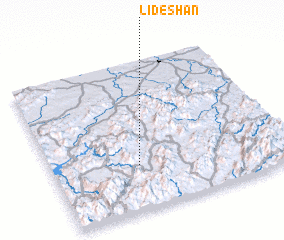 Places with similar names to Lideshan, China ::
// Ladychin (UA)
// Lutsheni (ZA)
// Lutsheni (ZA)
// Lodochnyy (RU)
// Lotoshino (RU)
// Lo de China (GT)
// Li-t'ou-shan (TW)
// Letaoshan (CN)
// Litoushan (CN)
// Luduishan (CN)
Disclaimer :: Information on this page comes without warranty of any kind |
||
|
Where is Lideshan? Elevation and coordinates ::
Latitude (lat): 30°18'0"N Longitude (lon): 118°22'0"E
Elevation (approx.): 298m (map arrows pan, magnifying glasses zoom) |
||
|
Visiting Lideshan? Hotel/Accommodation ::
Book a hotel in Lideshan Travel Guide ::
Buy a travel guide for China rental cars ::
car rental offers GPS waypoint ::
download a GPX waypoint (PoI) of Lideshan for your GPS receiver
|
||