|
search place name
|
||
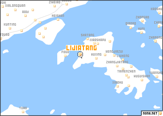
Lijiatang (Zhejiang, China)Lijiatang is a town in the Zhejiang region of China. An overview map of the region around Lijiatang is displayed below.
regional and 3d topo map of Lijiatang, China ::
Lijiatang airports ::
The nearest airport is NGB - Ninbo Lishe, located 59.1 km west of Lijiatang.
Other airports nearby include HGH - Hangzhou Xiaoshan (166.5 km west), SHA - Shanghai Hongqiao Intl (176.4 km north west), Nearby towns ::
Wuxing (2.9km east) //
Fodu (3.3km west) //
Longshan (4.3km north east) //
Shatang (4.5km north) //
Xiaoshapu (4.6km north east) //
Jiaotouzhen (4.7km east) //
Wengjiazui (6.5km east) //
Da'ao (6.8km north east) //
Zhangjiatang (7.4km east) //
Chachanggen (9.0km north west) //
Meishan (10.0km north west) //
Xiaohu (9.8km south east) //
Meishan (10.0km north west) //
[all distances 'as the bird flies' and approximate]  Places with similar names to Lijiatang, China ::
// Ljetinić (BA)
// Lagitenga (BF)
// Lijiadong (CN)
// Lijiatang (CN)
// Liujiading (CN)
// Liujiadong (CN)
// Liujiadong (CN)
// Lujiadang (CN)
// Lujiatang (CN)
// Luojiating (CN)
Disclaimer :: Information on this page comes without warranty of any kind |
||
|
Where is Lijiatang? Elevation and coordinates ::
Latitude (lat): 29°44'13"N Longitude (lon): 122°3'51"E
Elevation (approx.): 78m (map arrows pan, magnifying glasses zoom) |
||
|
Visiting Lijiatang? Hotel/Accommodation ::
Book a hotel in Lijiatang Travel Guide ::
Buy a travel guide for China rental cars ::
car rental offers GPS waypoint ::
download a GPX waypoint (PoI) of Lijiatang for your GPS receiver
|
||