|
search place name
|
||
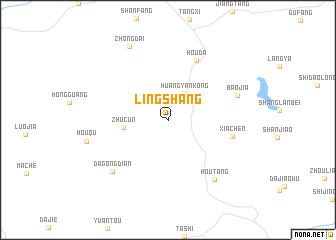
Lingshang (Zhejiang, China)Lingshang is a town in the Zhejiang region of China. An overview map of the region around Lingshang is displayed below.
regional and 3d topo map of Lingshang, China ::
Lingshang airports ::
The nearest airport is HGH - Hangzhou Xiaoshan, located 174.6 km north east of Lingshang.
Nearby towns ::
Huangyankong (3.4km north east) //
Zhucun (4.4km west) //
Houda (7.2km north east) //
Xiachen (6.6km east) //
Baojia (7.3km east) //
Dagongdian (7.9km south west) //
Houtang (8.1km south east) //
Zhongdai (9.1km north west) //
[all distances 'as the bird flies' and approximate]  Places with similar names to Lingshang, China ::
// Longching (IN)
// Longchong (LA)
// Lung-ching (TW)
// Lung-ching (TW)
// Lung-ch'ang (TW)
// Longsheng (CN)
// Longcheng (CN)
// Longchang (CN)
// Làng Chiêng (VN)
// Làng Chiêng (VN)
Disclaimer :: Information on this page comes without warranty of any kind |
||
|
Where is Lingshang? Elevation and coordinates ::
Latitude (lat): 28°57'0"N Longitude (lon): 119°23'0"E
Elevation (approx.): 519m (map arrows pan, magnifying glasses zoom) |
||
|
Visiting Lingshang? Hotel/Accommodation ::
Book a hotel in Lingshang Travel Guide ::
Buy a travel guide for China rental cars ::
car rental offers GPS waypoint ::
download a GPX waypoint (PoI) of Lingshang for your GPS receiver
|
||