|
search place name
|
||
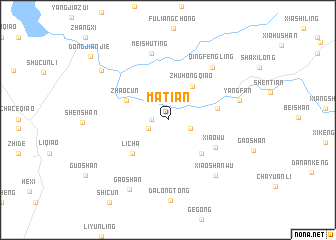
Matian (Anhui, China)Matian is a town in the Anhui region of China. An overview map of the region around Matian is displayed below.
regional and 3d topo map of Matian, China ::
Matian airports ::
The nearest airport is HFE - Hefei Luogang, located 177.6 km north of Matian.
Other airports nearby include KHN - Nanchang Changbei Intl (189.8 km south west), NKG - Nanjing Lukou (237.9 km north east), Nearby towns ::
Puqing (1.6km west) //
Dengcun (2.1km south west) //
Yanghuzhen (2.3km south east) //
Zhuhongqiao (4.4km north east) //
Zhaocun (4.6km north west) //
Dianlongjie (4.9km south east) //
Licha (5.1km south west) //
Hongshiqiao (5.0km east) //
Xiaowu (5.5km south east) //
Meishuting (7.6km north) //
Qingfengling (7.3km north east) //
Xiaoshanwu (7.7km south east) //
Yangfan (7.3km east) //
Gaoshan (8.6km south west) //
Talifeng (8.5km north west) //
Dongjianjie (10.3km north west) //
[all distances 'as the bird flies' and approximate] 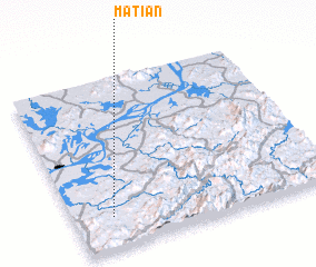 Places with similar names to Matian, China ::
Disclaimer :: Information on this page comes without warranty of any kind |
||
|
Where is Matian? Elevation and coordinates ::
Latitude (lat): 30°11'0"N Longitude (lon): 117°9'0"E
Elevation (approx.): 97m (map arrows pan, magnifying glasses zoom) |
||
|
Visiting Matian? Hotel/Accommodation ::
Book a hotel in Matian Travel Guide ::
Buy a travel guide for China rental cars ::
car rental offers GPS waypoint ::
download a GPX waypoint (PoI) of Matian for your GPS receiver
|
||