|
search place name
|
||
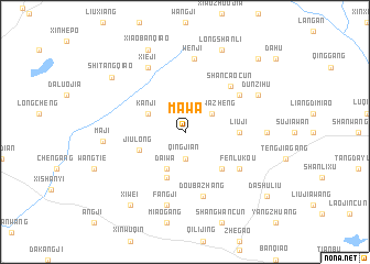
Mawa (Anhui, China)Mawa is a town in the Anhui region of China. An overview map of the region around Mawa is displayed below.
regional and 3d topo map of Mawa, China ::
Mawa airports ::
The nearest airport is HFE - Hefei Luogang, located 39.7 km west of Mawa.
Other airports nearby include NKG - Nanjing Lukou (111.1 km east), Nearby towns ::
Qingjian (2.8km south) //
Shanwazheng (3.0km north east) //
Daiwa (4.0km south west) //
Kanji (3.7km north west) //
Xiaoweiji (4.9km south) //
Xiafenma (4.9km south) //
Jiulong (4.3km south west) //
Dawangcun (4.9km south east) //
Liuji (4.7km east) //
Shancaocun (6.1km north east) //
Fenlukou (6.0km south east) //
Zhaoji (6.0km north east) //
Doubazhang (6.7km south) //
Wenji (7.5km north) //
Xieji (7.2km north west) //
Fangji (7.6km south) //
Dunzihu (7.3km north east) //
Shangxu (7.1km east) //
Maji (7.1km west) //
Longshanli (8.9km north) //
Xiaobanqiao (8.9km north) //
Xiwei (8.8km south west) //
Shitangqiao (8.4km north west) //
Caoxiang (9.7km north east) //
Dashuliu (9.6km south east) //
[all distances 'as the bird flies' and approximate] 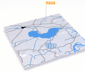 Places with similar names to Mawa, China ::
Disclaimer :: Information on this page comes without warranty of any kind |
||
|
Where is Mawa? Elevation and coordinates ::
Latitude (lat): 31°53'0"N Longitude (lon): 117°42'0"E
Elevation (approx.): 74m (map arrows pan, magnifying glasses zoom) |
||
|
Visiting Mawa? Hotel/Accommodation ::
Book a hotel in Mawa Travel Guide ::
Buy a travel guide for China rental cars ::
car rental offers GPS waypoint ::
download a GPX waypoint (PoI) of Mawa for your GPS receiver
|
||