|
search place name
|
||
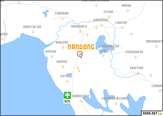
Nandong (Guangdong, China)Nandong is a town in the Guangdong region of China. An overview map of the region around Nandong is displayed below.
regional and 3d topo map of Nandong, China ::
Nandong airports ::
The nearest airport is SZX - Shenzhen Baoan Intl, located 9.1 km south of Nandong.
Other airports nearby include HKG - Hong Kong Intl (45.9 km south), MFM - Macau Intl (67.9 km south), CAN - Guangzhou Baiyun Intl (93.0 km north west), Nearby towns ::
Fenghuangwei (2.4km south) //
Lingxia (2.9km south) //
Heping (4.4km south west) //
Shajing (4.7km north west) //
Yulü (4.7km east) //
Shatou (5.6km north) //
Songgang (6.2km north) //
Fuyong (6.1km south west) //
Longwancun (6.2km east) //
Minzhu (6.3km west) //
Shutianbu (7.8km north east) //
Gongming (8.8km north east) //
[all distances 'as the bird flies' and approximate]  Places with similar names to Nandong, China ::
// Nandaung (MM)
// Nantaing (MM)
// Nantawnauk (MM)
// Nandoungué (CM)
// Niandianga (BJ)
// Nindangou (BF)
// Ninitenga (BF)
// Nantang (GH)
// Nanting (GH)
// Ninting (GH)
Disclaimer :: Information on this page comes without warranty of any kind |
||
|
Where is Nandong? Elevation and coordinates ::
Latitude (lat): 22°43'3"N Longitude (lon): 113°50'20"E
Elevation (approx.): 7m (map arrows pan, magnifying glasses zoom) |
||
|
Visiting Nandong? Hotel/Accommodation ::
Book a hotel in Nandong Travel Guide ::
Buy a travel guide for China rental cars ::
car rental offers GPS waypoint ::
download a GPX waypoint (PoI) of Nandong for your GPS receiver
|
||