|
search place name
|
||
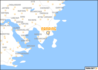
Nanping (Zhejiang, China)Nanping is a town in the Zhejiang region of China. An overview map of the region around Nanping is displayed below.
regional and 3d topo map of Nanping, China ::
Nanping airports ::
The nearest airport is MZW - Matsu Beigan, located 118.3 km south west of Nanping.
Other airports nearby include FOC - Fuzhou Changle (162.5 km south west), Nearby towns ::
Zhangcuo (1.3km south west) //
Chenjiaping (1.4km north) //
Luwei (2.5km north west) //
Chenghai (2.8km north west) //
Xiaguanzhen (3.7km south west) //
Sanxing (3.8km west) //
Lanshan (6.0km north) //
Yanpu (6.3km north west) //
Bitou (6.7km north west) //
Zhongkui (7.7km north) //
Tianliao (7.7km north) //
Kuili (7.8km north) //
Pucheng (7.5km north west) //
Yuliao (8.0km north) //
Shalingtou (7.6km west) //
Nanzhen (8.0km south west) //
Mazhanzhen (9.2km north west) //
[all distances 'as the bird flies' and approximate] 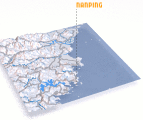 Places with similar names to Nanping, China ::
Disclaimer :: Information on this page comes without warranty of any kind |
||
|
Where is Nanping? Elevation and coordinates ::
Latitude (lat): 27°11'36"N Longitude (lon): 120°30'2"E
Elevation (approx.): 51m (map arrows pan, magnifying glasses zoom) |
||
|
Visiting Nanping? Hotel/Accommodation ::
Book a hotel in Nanping Travel Guide ::
Buy a travel guide for China rental cars ::
car rental offers GPS waypoint ::
download a GPX waypoint (PoI) of Nanping for your GPS receiver
|
||