|
search place name
|
||
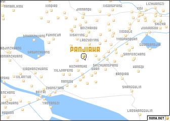
Panjiawa (Tianjin, China)Panjiawa is a town in the Tianjin region of China. An overview map of the region around Panjiawa is displayed below.
regional and 3d topo map of Panjiawa, China ::
Panjiawa airports ::
The nearest airport is TSN - Tianjin Binhai, located 25.3 km north of Panjiawa.
Other airports nearby include PEK - Beijing Capital Intl (148.2 km north west), Nearby towns ::
Zhongyixinzhuang (1.4km west) //
Erdaogou (2.2km north east) //
Wuzhanghe (2.5km south west) //
Jiajiawa (2.7km north west) //
Shuangzha (3.0km south) //
Shengziying (2.4km east) //
Da'an (3.3km south east) //
Xixiaozhan (3.6km south) //
Xizhenghe (3.5km south) //
Laozuoying (3.7km north) //
Xiaozhan (3.4km east) //
Huangfangzi (4.4km south) //
Qiazifang (4.1km north west) //
Liujiagou (4.0km south west) //
Shizhuangfang (4.0km south east) //
Yuanzhuangfang (3.8km east) //
Houying (4.5km north east) //
Xishiying (5.0km north) //
Zhanggangzi (5.1km south) //
Shijiuqing (5.1km south) //
Dongshiying (5.5km north) //
Yingxin (4.5km north east) //
Xilijiafeng (4.8km south west) //
Biweitai (5.9km south) //
Lutuozi (5.6km north east) //
Beizhakou (6.3km north) //
Tuozidi (5.1km east) //
Dongxiaogang (6.3km north east) //
Xihuayuan (5.7km north east) //
[all distances 'as the bird flies' and approximate]  Places with similar names to Panjiawa, China ::
Disclaimer :: Information on this page comes without warranty of any kind |
||
|
Where is Panjiawa? Elevation and coordinates ::
Latitude (lat): 38°53'56"N Longitude (lon): 117°23'13"E
Elevation (approx.): 2m (map arrows pan, magnifying glasses zoom) |
||
|
Visiting Panjiawa? Hotel/Accommodation ::
Book a hotel in Panjiawa Travel Guide ::
Buy a travel guide for China rental cars ::
car rental offers GPS waypoint ::
download a GPX waypoint (PoI) of Panjiawa for your GPS receiver
|
||