|
search place name
|
||
Qili (Zhejiang, China)Qili is a town in the Zhejiang region of China. An overview map of the region around Qili is displayed below.
regional and 3d topo map of Qili, China ::

Qili airports ::
The nearest airport is HGH - Hangzhou Xiaoshan, located 113.8 km east of Qili.
Other airports nearby include NKG - Nanjing Lukou (160.5 km north), HFE - Hefei Luogang (246.3 km north west), Nearby towns ::
Tonglingguan (1.7km north) //
Xiejiaqiao (5.0km south) //
Yunti (4.9km north east) //
Niangniangwu (5.3km west) //
Yangshan (6.4km north) //
Henglutou (6.1km south east) //
Banzhuwu (7.0km south east) //
Shenjia (8.0km south) //
Tanggeng (7.2km west) //
Shangshanwa (7.7km north west) //
Xianxia (8.6km north) //
Tongzi'an (7.8km west) //
Taoshuling (9.1km south) //
[all distances 'as the bird flies' and approximate] 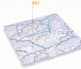 Places with similar names to Qili, China ::
Disclaimer :: Information on this page comes without warranty of any kind |
||
|
Where is Qili? Elevation and coordinates ::
Latitude (lat): 30°20'6"N Longitude (lon): 119°15'30"E
Elevation (approx.): 465m (map arrows pan, magnifying glasses zoom) |
||
|
Visiting Qili? Hotel/Accommodation ::
Book a hotel in Qili Travel Guide ::
Buy a travel guide for China rental cars ::
car rental offers GPS waypoint ::
download a GPX waypoint (PoI) of Qili for your GPS receiver
|
||