|
search place name
|
||
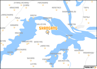
Shaogang (Anhui, China)Shaogang is a town in the Anhui region of China. An overview map of the region around Shaogang is displayed below.
regional and 3d topo map of Shaogang, China ::
Shaogang airports ::
The nearest airport is NKG - Nanjing Lukou, located 151.0 km south east of Shaogang.
Other airports nearby include HFE - Hefei Luogang (153.9 km south west), Nearby towns ::
Dalinying (3.9km north west) //
Dengying (5.0km south west) //
Jiangying (5.5km south) //
Wanggang (5.6km north) //
Liutiaochong (6.0km south east) //
Jiuxian (6.8km east) //
Dayingji (7.3km south west) //
Gaozui (8.1km north west) //
Zhengshang (8.7km south) //
Sangdaying (7.9km south west) //
Fengying (8.5km south east) //
Donglijia (8.3km north west) //
Shuangpaolou (10.5km north east) //
[all distances 'as the bird flies' and approximate] 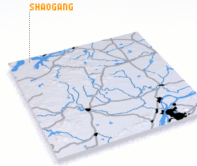 Places with similar names to Shaogang, China ::
// Shaohkang (MM)
// Sha-u Hkang (MM)
// Shu-u-kawng (MM)
// Chignik (US)
// Chia Keng (SG)
// Shkinak (AL)
// Shakung (ZA)
// Chiganak (RU)
// Chiganak (RU)
// Chiganaki (RU)
Disclaimer :: Information on this page comes without warranty of any kind |
||
|
Where is Shaogang? Elevation and coordinates ::
Latitude (lat): 32°57'50"N Longitude (lon): 118°9'10"E
Elevation (approx.): 39m (map arrows pan, magnifying glasses zoom) |
||
|
Visiting Shaogang? Hotel/Accommodation ::
Book a hotel in Shaogang Travel Guide ::
Buy a travel guide for China rental cars ::
car rental offers GPS waypoint ::
download a GPX waypoint (PoI) of Shaogang for your GPS receiver
|
||