|
search place name
|
||
Sujiakeng (Fujian, China)Sujiakeng is a town in the Fujian region of China. An overview map of the region around Sujiakeng is displayed below.
regional and 3d topo map of Sujiakeng, China ::

Sujiakeng airports ::
The nearest airport is MZW - Matsu Beigan, located 128.0 km south of Sujiakeng.
Other airports nearby include FOC - Fuzhou Changle (168.9 km south), Nearby towns ::
Niutiyang (1.8km south east) //
Qiaoting (2.6km north east) //
Tantouwan (3.1km south) //
Wuyang (3.2km east) //
Qidou (3.5km north west) //
Zhoucuo (3.8km west) //
Cai'aonei (4.6km south) //
Qianqizhen (4.6km south east) //
Huangren (4.9km north) //
Xueqiao (5.0km south) //
Xizhai (5.0km south east) //
Fengtong (4.9km east) //
Wencuo (5.3km south west) //
Guoyangping (5.1km south west) //
Xiongling (5.2km north east) //
Jialong (5.8km north) //
Wufeng (6.1km north) //
Junying (5.8km north west) //
Guiling (5.8km east) //
Jiepingneicuo (7.2km north) //
Fengcun (7.3km north east) //
Puping (7.3km east) //
Wayaopu (8.0km north east) //
Degongting (8.4km north west) //
Bilingjiao (8.6km north) //
Shaocuo (8.7km south) //
Liyang (8.7km north) //
Fuding (8.0km west) //
Sumuyang (8.7km south east) //
[all distances 'as the bird flies' and approximate] 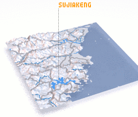 Places with similar names to Sujiakeng, China ::
Disclaimer :: Information on this page comes without warranty of any kind |
||
|
Where is Sujiakeng? Elevation and coordinates ::
Latitude (lat): 27°20'57"N Longitude (lon): 120°17'46"E
Elevation (approx.): 193m (map arrows pan, magnifying glasses zoom) |
||
|
Visiting Sujiakeng? Hotel/Accommodation ::
Book a hotel in Sujiakeng Travel Guide ::
Buy a travel guide for China rental cars ::
car rental offers GPS waypoint ::
download a GPX waypoint (PoI) of Sujiakeng for your GPS receiver
|
||