|
search place name
|
||
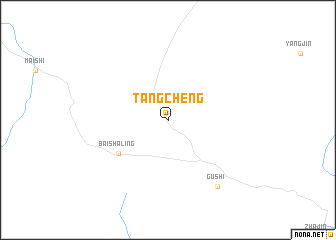
Tangcheng (Jiangxi, China)Tangcheng is a town in the Jiangxi region of China. An overview map of the region around Tangcheng is displayed below.
regional and 3d topo map of Tangcheng, China ::
Tangcheng airports ::
The nearest airport is CSX - Changcha Huanghua, located 133.0 km south west of Tangcheng.
Other airports nearby include KHN - Nanchang Changbei Intl (179.2 km east), WUH - Wuhan Tianhe (185.2 km north), Nearby towns ::
Baishaling (6.1km south west) //
Gushi (8.9km south east) //
[all distances 'as the bird flies' and approximate]  Places with similar names to Tangcheng, China ::
// Taungchaung (MM)
// Taungchaung (MM)
// Tongch'ang (KP)
// Tongch'ang (KR)
// Tongch'ang (KR)
// Tongch'ang (KR)
// Tongch'ang (KR)
// Tongch'ang (KP)
// Tien-k'ou-chuang (TW)
// Ting-ch'eng (TW)
Disclaimer :: Information on this page comes without warranty of any kind |
||
|
Where is Tangcheng? Elevation and coordinates ::
Latitude (lat): 29°7'0"N Longitude (lon): 114°5'0"E
Elevation (approx.): 519m (map arrows pan, magnifying glasses zoom) |
||
|
Visiting Tangcheng? Hotel/Accommodation ::
Book a hotel in Tangcheng Travel Guide ::
Buy a travel guide for China rental cars ::
car rental offers GPS waypoint ::
download a GPX waypoint (PoI) of Tangcheng for your GPS receiver
|
||