|
search place name
|
||
Wangkeng (Fujian, China)Wangkeng is a town in the Fujian region of China. An overview map of the region around Wangkeng is displayed below.
regional and 3d topo map of Wangkeng, China ::

Wangkeng airports ::
The nearest airport is FOC - Fuzhou Changle, located 51.0 km north east of Wangkeng.
Other airports nearby include MZW - Matsu Beigan (96.4 km north east), KNH - Chinmen Shang Yi (168.5 km south west), XMN - Xiamen Gaoqi (171.2 km south west), Nearby towns ::
Qiaotou (1.9km south) //
Xindongzhang (3.3km east) //
Yuanwei (6.8km south) //
Duntou (6.3km east) //
Nanling (6.3km west) //
Lingxia (6.6km south west) //
Dongzhang (6.7km south east) //
Shuangxi (8.9km south) //
Houxi (8.7km north west) //
Lingtou (11.1km north west) //
[all distances 'as the bird flies' and approximate] 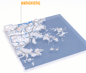 Places with similar names to Wangkeng, China ::
// Wong Cung (ID)
// Wāngkawng (MM)
// Wān Kio-keng (MM)
// Wengkang (MM)
// Wangcunkou (CN)
// Wangguaigang (CN)
// Wangkeng (CN)
// Wangkeng (CN)
// Wangqing (CN)
// Wang-kung (TW)
Disclaimer :: Information on this page comes without warranty of any kind |
||
|
Where is Wangkeng? Elevation and coordinates ::
Latitude (lat): 25°44'29"N Longitude (lon): 119°12'5"E
Elevation (approx.): 275m (map arrows pan, magnifying glasses zoom) |
||
|
Visiting Wangkeng? Hotel/Accommodation ::
Book a hotel in Wangkeng Travel Guide ::
Buy a travel guide for China rental cars ::
car rental offers GPS waypoint ::
download a GPX waypoint (PoI) of Wangkeng for your GPS receiver
|
||