|
search place name
|
||
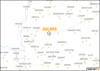
Wulong (Zhejiang, China)Wulong is a town in the Zhejiang region of China. An overview map of the region around Wulong is displayed below.
regional and 3d topo map of Wulong, China ::
Wulong airports ::
The nearest airport is NGB - Ninbo Lishe, located 179.5 km north of Wulong.
Other airports nearby include HGH - Hangzhou Xiaoshan (217.1 km north), Nearby towns ::
Tianliao (2.8km east) //
Langxia (4.4km south) //
Gushan (4.7km north west) //
Huatan (5.3km south west) //
Xiaduan (4.8km west) //
Shuangxi (5.5km south east) //
Jinshan (5.8km west) //
Tang'ao (6.1km west) //
Yanshang (7.1km north east) //
Wulongchuan (7.4km south) //
Dongzhang (7.4km south) //
Dongcun (7.1km south west) //
Pengxi (7.6km north) //
Shanshang (7.8km north) //
Donglu (7.6km north west) //
Hesheng (8.0km north) //
Gumiao (8.0km south) //
Gumiao (8.0km south) //
Huangcun (7.6km south west) //
Fenglin (7.7km west) //
Bao'ao (7.7km west) //
Shangluyang (8.9km south west) //
Donggao (9.2km north) //
Xiataitou (9.2km south east) //
Linggen (9.6km north east) //
[all distances 'as the bird flies' and approximate] 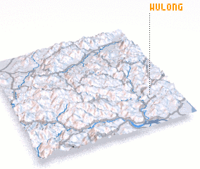 Places with similar names to Wulong, China ::
Disclaimer :: Information on this page comes without warranty of any kind |
||
|
Where is Wulong? Elevation and coordinates ::
Latitude (lat): 28°18'11"N Longitude (lon): 120°50'16"E
Elevation (approx.): 550m (map arrows pan, magnifying glasses zoom) |
||
|
Visiting Wulong? Hotel/Accommodation ::
Book a hotel in Wulong Travel Guide ::
Buy a travel guide for China rental cars ::
car rental offers GPS waypoint ::
download a GPX waypoint (PoI) of Wulong for your GPS receiver
|
||