|
search place name
|
||
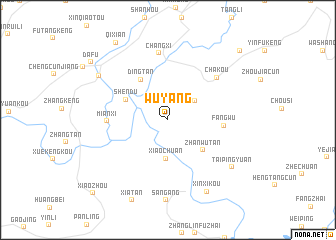
Wuyang (Anhui, China)Wuyang is a town in the Anhui region of China. An overview map of the region around Wuyang is displayed below.
regional and 3d topo map of Wuyang, China ::
Wuyang airports ::
The nearest airport is HGH - Hangzhou Xiaoshan, located 177.0 km east of Wuyang.
Other airports nearby include NKG - Nanjing Lukou (211.0 km north), HFE - Hefei Luogang (250.4 km north west), Nearby towns ::
Qiahe (3.4km north east) //
Xiaochuan (4.3km south) //
Zhanwutan (4.8km south east) //
Shendu (4.6km north west) //
Dingtan (5.2km north west) //
Fangwu (5.4km east) //
Mianxi (5.9km west) //
Chakou (6.7km north east) //
Changxi (7.5km north) //
Taipingyuan (8.1km south east) //
Xinxikou (8.9km south east) //
Tangkeng (8.3km north west) //
Qixian (10.0km north west) //
Dafu (9.9km north west) //
Jingtan (10.4km north east) //
Xiaozhou (11.0km south west) //
[all distances 'as the bird flies' and approximate]  Places with similar names to Wuyang, China ::
Disclaimer :: Information on this page comes without warranty of any kind |
||
|
Where is Wuyang? Elevation and coordinates ::
Latitude (lat): 29°50'50"N Longitude (lon): 118°39'9"E
Elevation (approx.): 147m (map arrows pan, magnifying glasses zoom) |
||
|
Visiting Wuyang? Hotel/Accommodation ::
Book a hotel in Wuyang Travel Guide ::
Buy a travel guide for China rental cars ::
car rental offers GPS waypoint ::
download a GPX waypoint (PoI) of Wuyang for your GPS receiver
|
||