|
search place name
|
||
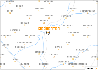
Xiaonantan (Jiangsu, China)Xiaonantan is a town in the Jiangsu region of China. An overview map of the region around Xiaonantan is displayed below.
regional and 3d topo map of Xiaonantan, China ::
Xiaonantan airports ::
The nearest airport is NKG - Nanjing Lukou, located 244.8 km south west of Xiaonantan.
Nearby towns ::
Haiguan (4.9km north) //
Shangwa (6.5km north) //
Xintan (6.4km south east) //
Chenzhuang (6.2km west) //
Mutouwuzi (6.8km north east) //
Bazhuang (8.0km south west) //
Anwa (7.2km south east) //
Xinzhong (8.5km south) //
Chenyang (8.4km north east) //
Tangwa (8.9km north west) //
[all distances 'as the bird flies' and approximate]  Places with similar names to Xiaonantan, China ::
// San Antônio (BR)
// San Antonio (BZ)
// San Antonio (BZ)
// San Antonio (BZ)
// San Antonio (BZ)
// San Antonio (US)
// San Antonio (US)
// San Antonio (US)
// San Antonio (PA)
// San Antonio (PA)
Disclaimer :: Information on this page comes without warranty of any kind |
||
|
Where is Xiaonantan? Elevation and coordinates ::
Latitude (lat): 33°42'30"N Longitude (lon): 120°3'0"E
Elevation (approx.): -1m (map arrows pan, magnifying glasses zoom) |
||
|
Visiting Xiaonantan? Hotel/Accommodation ::
Book a hotel in Xiaonantan Travel Guide ::
Buy a travel guide for China rental cars ::
car rental offers GPS waypoint ::
download a GPX waypoint (PoI) of Xiaonantan for your GPS receiver
|
||