|
search place name
|
||
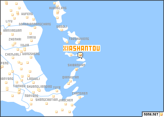
Xiashantou (Zhejiang, China)Xiashantou is a town in the Zhejiang region of China. An overview map of the region around Xiashantou is displayed below.
regional and 3d topo map of Xiashantou, China ::
Xiashantou airports ::
The nearest airport is NGB - Ninbo Lishe, located 156.8 km north of Xiashantou.
Other airports nearby include HGH - Hangzhou Xiaoshan (233.0 km north west), Nearby towns ::
Shang'ao (2.3km west) //
Shibandian (2.7km south west) //
Longmen (2.8km south) //
Taoshuikeng (3.7km north) //
Dongshantou (4.8km north west) //
Qianwuyan (5.7km south west) //
Longwangshantou (6.3km south west) //
Da'aoli (7.6km north west) //
Changmen (8.9km south) //
Yuye (9.0km south west) //
Songmenzhen (10.4km south west) //
[all distances 'as the bird flies' and approximate] 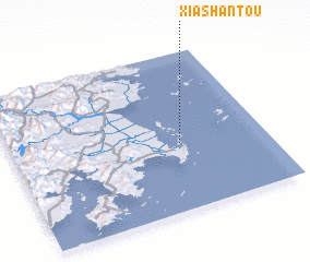 Places with similar names to Xiashantou, China ::
// Zachenöd (DE)
// Sachendi (IN)
// Sashinde (ZM)
// Seshonda (ZM)
// Sichindi (ZM)
// Sichonda (ZM)
// Sachinda (MZ)
// Xiashantou (CN)
// Sushantou (CN)
// Xiaoshentou (CN)
Disclaimer :: Information on this page comes without warranty of any kind |
||
|
Where is Xiashantou? Elevation and coordinates ::
Latitude (lat): 28°25'22"N Longitude (lon): 121°39'42"E
Elevation (approx.): 71m (map arrows pan, magnifying glasses zoom) |
||
|
Visiting Xiashantou? Hotel/Accommodation ::
Book a hotel in Xiashantou Travel Guide ::
Buy a travel guide for China rental cars ::
car rental offers GPS waypoint ::
download a GPX waypoint (PoI) of Xiashantou for your GPS receiver
|
||