|
search place name
|
||
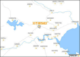
Xitianwei (Fujian, China)Xitianwei is a town in the Fujian region of China. An overview map of the region around Xitianwei is displayed below.
regional and 3d topo map of Xitianwei, China ::
Xitianwei airports ::
The nearest airport is FOC - Fuzhou Changle, located 80.5 km north east of Xitianwei.
Other airports nearby include MZW - Matsu Beigan (127.1 km north east), KNH - Chinmen Shang Yi (134.6 km south west), XMN - Xiamen Gaoqi (138.2 km south west), MZG - Makung Magong (218.2 km south), Nearby towns ::
Wutang (4.4km north east) //
Zhenqian (5.1km south east) //
Putian (5.0km south west) //
Hanjiang (5.7km east) //
Songban (5.9km north east) //
Qingjiang (6.3km south) //
Baitang (6.7km south east) //
Zhuopo (6.6km east) //
Guohuan (6.7km east) //
Sanjiangkou (7.1km south east) //
Xinpu (7.5km south east) //
Tangtou (7.9km east) //
Duotou (8.2km south east) //
Qiulu (9.0km north east) //
Dongjia (10.5km south east) //
[all distances 'as the bird flies' and approximate] 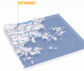 Places with similar names to Xitianwei, China ::
// Sucha Nowa (PL)
// Żochy Nowe (PL)
// Xiaoshanwu (CN)
// Xiashanwu (CN)
// Xieshunwei (CN)
// Xueshanwu (CN)
Disclaimer :: Information on this page comes without warranty of any kind |
||
|
Where is Xitianwei? Elevation and coordinates ::
Latitude (lat): 25°28'0"N Longitude (lon): 119°3'0"E
Elevation (approx.): 7m (map arrows pan, magnifying glasses zoom) |
||
|
Visiting Xitianwei? Hotel/Accommodation ::
Book a hotel in Xitianwei Travel Guide ::
Buy a travel guide for China rental cars ::
car rental offers GPS waypoint ::
download a GPX waypoint (PoI) of Xitianwei for your GPS receiver
|
||