|
search place name
|
||
Yangtaolou (Anhui, China)Yangtaolou is a town in the Anhui region of China. An overview map of the region around Yangtaolou is displayed below.
regional and 3d topo map of Yangtaolou, China ::
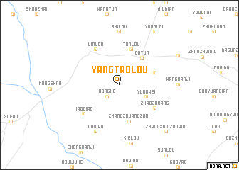
Nearby towns ::
Honghe (2.4km south west) //
Guoyoufang (2.4km north west) //
Yuanwei (4.0km south east) //
Datun (5.1km north east) //
Tanlou (5.8km north) //
Guanzhuang (5.0km east) //
Zhangzhuangzhai (5.9km south) //
Zhaozhuang (5.9km south east) //
Linlou (6.3km north west) //
Maoqiao (6.5km south west) //
Oumiao (8.0km south) //
Shilou (8.3km north) //
Yanglou (9.5km north east) //
Zhangxingzhuang (9.6km south east) //
[all distances 'as the bird flies' and approximate] 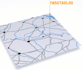 Places with similar names to Yangtaolou, China ::
// Youngdale (US)
// Hyŏngt'al-li (KP)
// Yongdae il-li (KR)
// Yongt'aeul (KR)
// Yangt'al-li (KP)
// Yŏngdal (KP)
// Yongt'al-li (KP)
// Yongt'al-li (KP)
Disclaimer :: Information on this page comes without warranty of any kind |
||
|
Where is Yangtaolou? Elevation and coordinates ::
Latitude (lat): 34°11'0"N Longitude (lon): 116°35'0"E
Elevation (approx.): 40m (map arrows pan, magnifying glasses zoom) |
||
|
Visiting Yangtaolou? Hotel/Accommodation ::
Book a hotel in Yangtaolou Travel Guide ::
Buy a travel guide for China rental cars ::
car rental offers GPS waypoint ::
download a GPX waypoint (PoI) of Yangtaolou for your GPS receiver
|
||