|
search place name
|
||
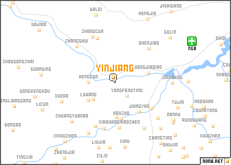
Yinjiang (Zhejiang, China)Yinjiang is a town in the Zhejiang region of China. An overview map of the region around Yinjiang is displayed below.
regional and 3d topo map of Yinjiang, China ::
Yinjiang airports ::
The nearest airport is NGB - Ninbo Lishe, located 12.7 km north east of Yinjiang.
Other airports nearby include HGH - Hangzhou Xiaoshan (102.2 km north west), SHA - Shanghai Hongqiao Intl (158.7 km north), Nearby towns ::
Yongfengting (2.7km south east) //
Hengcun (3.8km west) //
Chanyanyan (4.2km south west) //
Luwang (4.7km south west) //
Wangjiaqiao (4.8km east) //
Dulangping (5.7km south) //
Houzhu (5.9km south) //
Jiangyan (5.8km south east) //
Jiangkouzhen (6.6km south east) //
Xiaowangmiaozhen (7.3km south) //
Xiaozhen (7.6km south) //
Shenjiao (7.3km north east) //
Maojia'ao (7.7km north) //
Dazhang (7.6km south) //
Zhangcun (8.1km north west) //
Zhangshui (8.0km north west) //
Xiaoqiaotou (8.4km south east) //
Jiangjiapu (8.3km south east) //
Xue'ao (8.2km west) //
Jishan (9.1km south west) //
Zhuangyuan'ao (8.9km south west) //
Zhengjiata (9.7km south east) //
[all distances 'as the bird flies' and approximate]  Places with similar names to Yinjiang, China ::
Disclaimer :: Information on this page comes without warranty of any kind |
||
|
Where is Yinjiang? Elevation and coordinates ::
Latitude (lat): 29°46'0"N Longitude (lon): 121°21'0"E
Elevation (approx.): 24m (map arrows pan, magnifying glasses zoom) |
||
|
Visiting Yinjiang? Hotel/Accommodation ::
Book a hotel in Yinjiang Travel Guide ::
Buy a travel guide for China rental cars ::
car rental offers GPS waypoint ::
download a GPX waypoint (PoI) of Yinjiang for your GPS receiver
|
||