|
search place name
|
||
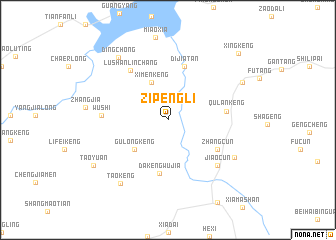
Zipengli (Anhui, China)Zipengli is a town in the Anhui region of China. An overview map of the region around Zipengli is displayed below.
regional and 3d topo map of Zipengli, China ::
Zipengli airports ::
The nearest airport is HFE - Hefei Luogang, located 183.4 km north of Zipengli.
Other airports nearby include NKG - Nanjing Lukou (184.5 km north east), Nearby towns ::
Ximenkeng (4.5km north) //
Gulongkeng (4.6km south west) //
Dakengwujia (6.1km south) //
Dijiatan (6.2km north) //
Zhangcun (5.8km south east) //
Qulankeng (5.7km east) //
Lushan Linchang (6.6km north west) //
Wushi (6.4km west) //
Jiaocun (7.0km south east) //
Yanghu Linchang (7.6km south east) //
Dingchong (8.4km north west) //
Taokeng (8.5km south west) //
Xianyuanyichang (8.3km north east) //
Taoyuan (8.8km south west) //
Xingkeng (10.1km north east) //
[all distances 'as the bird flies' and approximate] 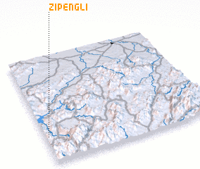 Places with similar names to Zipengli, China ::
// Sipangula (ZM)
// Sipangule (ZM)
// Spīn Kili (PK)
// Spīn Killa (PK)
// Sponi Kalle (PK)
// Zepingle (HT)
// Hsi-p'ing-liao (TW)
// Spīneh Kalā (AF)
// Spangle (US)
// Sepänkylä (FI)
Disclaimer :: Information on this page comes without warranty of any kind |
||
|
Where is Zipengli? Elevation and coordinates ::
Latitude (lat): 30°14'45"N Longitude (lon): 118°1'0"E
Elevation (approx.): 278m (map arrows pan, magnifying glasses zoom) |
||
|
Visiting Zipengli? Hotel/Accommodation ::
Book a hotel in Zipengli Travel Guide ::
Buy a travel guide for China rental cars ::
car rental offers GPS waypoint ::
download a GPX waypoint (PoI) of Zipengli for your GPS receiver
|
||