|
search place name
|
||
Al Bayḑāʼ (‘Adan, Yemen)Al Bayḑāʼ is a town in the ‘Adan region of Yemen. An overview map of the region around Al Bayḑāʼ is displayed below.
regional and 3d topo map of Al Bayḑāʼ, Yemen ::
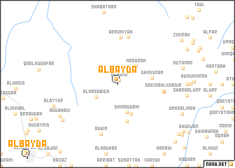
Nearby towns ::
Al Ḩanw (0.7km north east) //
Ḩijlān (3.9km north east) //
Al Masābigh (3.8km south west) //
Masūrah (4.0km north east) //
Dhī Maḑḑāḩī (4.8km south) //
Umm Ḩamrāʼ (5.2km south east) //
Dhī Misnām (5.5km east) //
Sabbāḩ (6.1km south) //
Sākin Ahl Khādir (7.1km east) //
Ar Rūmīyah (7.4km north) //
Maḩraq (7.3km east) //
Ar Rūmīyah (7.7km north) //
Awwīn (8.4km south) //
Shawkān (10.2km south west) //
[all distances 'as the bird flies' and approximate] 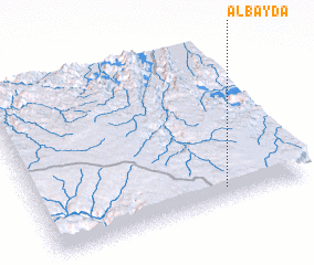 Places with similar names to Al Bayḑāʼ, Yemen ::
Disclaimer :: Information on this page comes without warranty of any kind |
||
|
Where is Al Bayḑāʼ? Elevation and coordinates ::
Latitude (lat): 14°5'0"N Longitude (lon): 45°42'0"E
Elevation (approx.): 1999m (map arrows pan, magnifying glasses zoom) |
||
|
Visiting Al Bayḑāʼ? Hotel/Accommodation ::
Book a hotel in Al Bayḑāʼ Travel Guide ::
Buy a travel guide for Yemen rental cars ::
car rental offers GPS waypoint ::
download a GPX waypoint (PoI) of Al Bayḑāʼ for your GPS receiver
|
||