|
search place name
|
||
Al Man‘ūm (Ta‘izz, Yemen)Al Man‘ūm is a town in the Ta‘izz region of Yemen. An overview map of the region around Al Man‘ūm is displayed below.
regional and 3d topo map of Al Man‘ūm, Yemen ::
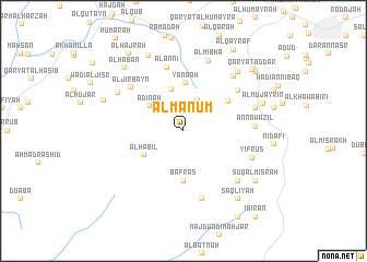
Nearby towns ::
Al Miḩshāʼ (2.7km north) //
Qaryat Wādī al Biʼr (3.4km north east) //
Adīnah (4.2km north west) //
Qashībah (4.4km north) //
Al Ḩabīl (4.6km south west) //
Yanā‘ah (4.9km north) //
Bafras (5.1km south) //
Wādī al Aḩmar Hajam (5.4km north east) //
Al ‘Annī (6.7km north) //
Al Jirbayn (6.8km north west) //
Manājid aḑ Ḑabāb (6.8km north east) //
Banī Khawlān (7.2km south) //
An Nawāzil (7.2km east) //
Yifrus (7.4km east) //
Ghufayrah (7.4km south east) //
Maslaqah (7.5km north east) //
Al Mibhā (7.6km north) //
Al Khalfah (7.5km north west) //
‘Adan (7.6km east) //
‘Asāb (8.1km north east) //
Aş Şarāhim (8.4km north west) //
Al Mujayrīn (8.4km east) //
Ḩarāz (8.5km west) //
Al Habān (8.7km north west) //
Şaqlīyah (8.8km south east) //
Sūq al Misrāḩ (8.8km south east) //
Qaryat ad Dār (9.2km north east) //
Al Ma‘labah (9.4km north east) //
Al Hajrah (9.6km north west) //
[all distances 'as the bird flies' and approximate]  Places with similar names to Al Man‘ūm, Yemen ::
Disclaimer :: Information on this page comes without warranty of any kind |
||
|
Where is Al Man‘ūm? Elevation and coordinates ::
Latitude (lat): 13°28'45"N Longitude (lon): 43°53'0"E
Elevation (approx.): 2101m (map arrows pan, magnifying glasses zoom) |
||
|
Visiting Al Man‘ūm? Hotel/Accommodation ::
Book a hotel in Al Man‘ūm Travel Guide ::
Buy a travel guide for Yemen rental cars ::
car rental offers GPS waypoint ::
download a GPX waypoint (PoI) of Al Man‘ūm for your GPS receiver
|
||