|
search place name
|
||
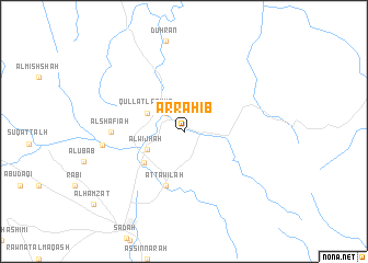
Ar Raḩīb (‘Adan, Yemen)Ar Raḩīb is a town in the ‘Adan region of Yemen. An overview map of the region around Ar Raḩīb is displayed below.
regional and 3d topo map of Ar Raḩīb, Yemen ::
Ar Raḩīb airports ::
The nearest airport is EAM - Nejran, located 90.5 km north east of Ar Raḩīb.
Other airports nearby include GIZ - Gizan King Abdullah Bin Abdulaziz (131.9 km west), AHB - Abha (181.7 km north west), Nearby towns ::
Nushūr (2.6km north west) //
Makrān (4.0km south west) //
Al Wijhah (4.0km south west) //
Qullāt Lashūr (4.0km north west) //
Aţ Ţawīlah (5.0km south west) //
Aţ Ţawīlah (5.8km south) //
Āl Shāfi‘ah (7.1km west) //
Rubī‘ (8.1km west) //
[all distances 'as the bird flies' and approximate]  Places with similar names to Ar Raḩīb, Yemen ::
// Ar Rāhib (EG)
// Ar Riḩāb (SA)
// Ar Raḩab (SD)
// Ar Rahèba (LY)
// Arḩāb (SY)
// Arḩabī (SY)
// Ar Rāhib (SY)
// Ar Ruḩaybah (SY)
// Ar Ruḩaybah (SY)
// Ar Raḩabah (YE)
Disclaimer :: Information on this page comes without warranty of any kind |
||
|
Where is Ar Raḩīb? Elevation and coordinates ::
Latitude (lat): 17°2'0"N Longitude (lon): 43°49'0"E
Elevation (approx.): 1839m (map arrows pan, magnifying glasses zoom) |
||
|
Visiting Ar Raḩīb? Hotel/Accommodation ::
Book a hotel in Ar Raḩīb Travel Guide ::
Buy a travel guide for Yemen rental cars ::
car rental offers GPS waypoint ::
download a GPX waypoint (PoI) of Ar Raḩīb for your GPS receiver
|
||