|
search place name
|
||
Ar Raydah (‘Adan, Yemen)Ar Raydah is a town in the ‘Adan region of Yemen. An overview map of the region around Ar Raydah is displayed below.
regional and 3d topo map of Ar Raydah, Yemen ::
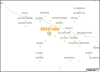
Nearby towns ::
Al Ḩujayl (0.0km north) //
Ash Shujayn (1.8km east) //
An Nuqayyib (2.6km south west) //
Aţ Ţirāf (2.6km south west) //
Al ‘Ujaymah (3.7km north) //
Ar Rabasah (4.1km north east) //
‘Amīq (4.1km north east) //
Ar Rukḩ (5.2km north east) //
Mikrāb (5.2km south west) //
Al Junaynah (5.4km east) //
Al Bāridah (5.6km north) //
Al Furuţ (5.7km east) //
Ḩayd Bin Na‘āmir (5.7km east) //
Ḩayd ad Daqīqah (6.6km north east) //
Al Karīf (6.6km north west) //
Al Jirbah (7.2km east) //
Maqarr (7.2km east) //
Al Jayf (7.4km east) //
Ash Shiqq (7.6km north) //
Al Ḩadd (8.2km south west) //
[all distances 'as the bird flies' and approximate]  Places with similar names to Ar Raydah, Yemen ::
Disclaimer :: Information on this page comes without warranty of any kind |
||
|
Where is Ar Raydah? Elevation and coordinates ::
Latitude (lat): 14°53'0"N Longitude (lon): 47°1'0"E
Elevation (approx.): 1219m (map arrows pan, magnifying glasses zoom) |
||
|
Visiting Ar Raydah? Hotel/Accommodation ::
Book a hotel in Ar Raydah Travel Guide ::
Buy a travel guide for Yemen rental cars ::
car rental offers GPS waypoint ::
download a GPX waypoint (PoI) of Ar Raydah for your GPS receiver
|
||