|
search place name
|
||
As Sarīd (‘Adan, Yemen)As Sarīd is a town in the ‘Adan region of Yemen. An overview map of the region around As Sarīd is displayed below.
regional and 3d topo map of As Sarīd, Yemen ::
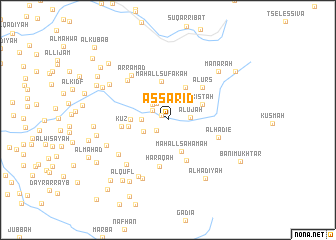
Nearby towns ::
Al Mandam (0.9km north west) //
Mushrifah (1.7km south west) //
Sanīf Mahdī (2.0km north west) //
Maḩall Khābiyah (2.2km north west) //
Aluja (2.4km north west) //
‘Alūjah (2.4km east) //
Al ‘Asaqah (2.9km west) //
Al Waşf (3.0km south west) //
Maḩall Saḩamah (3.8km south east) //
Janbat ash Sharīf (4.1km north east) //
Kistah (4.1km north east) //
Kabbat Yaḩyá Hibah (4.1km west) //
Maḩall Sufākah (4.4km north) //
Al Wuqay‘ (4.3km west) //
Al Miqţar (5.0km south east) //
Al ‘Urs (5.2km north east) //
Kūz (5.1km west) //
Ḩaraqah (5.3km south) //
Al Hadie (5.8km east) //
Al ‘Āriḑ (6.2km north west) //
Ar Ramād (6.4km north west) //
Al Jabīl (6.6km south west) //
Ad Dimnah (6.7km south west) //
Al Jirbah (7.1km south west) //
Al Hajāmīyah (7.1km south west) //
Al Mulayţah (7.2km south west) //
Khadd al Kalb (7.5km north west) //
Al Ḩadīyah (7.7km south east) //
Manārah (7.7km north east) //
[all distances 'as the bird flies' and approximate] 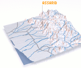 Places with similar names to As Sarīd, Yemen ::
// Aouzert (MA)
// Aouzert (MA)
// Azrou Ouado (MA)
// Ausserroid (AT)
// Acereto (IT)
// Az Zārāt (TN)
// Acered (ES)
// Acereda (ES)
// Asarta (ES)
// Azrat (IR)
Disclaimer :: Information on this page comes without warranty of any kind |
||
|
Where is As Sarīd? Elevation and coordinates ::
Latitude (lat): 14°35'4"N Longitude (lon): 43°31'56"E
Elevation (approx.): 420m (map arrows pan, magnifying glasses zoom) |
||
|
Visiting As Sarīd? Hotel/Accommodation ::
Book a hotel in As Sarīd Travel Guide ::
Buy a travel guide for Yemen rental cars ::
car rental offers GPS waypoint ::
download a GPX waypoint (PoI) of As Sarīd for your GPS receiver
|
||