|
search place name
|
||
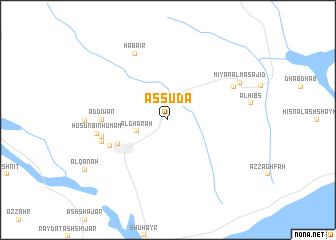
Aş Şudā‘ (‘Adan, Yemen)Aş Şudā‘ is a town in the ‘Adan region of Yemen. An overview map of the region around Aş Şudā‘ is displayed below.
regional and 3d topo map of Aş Şudā‘, Yemen ::
Nearby towns ::
Al Ghārah (3.6km west) //
Ghayl Bā Wazīr (6.0km south west) //
Al Mukhtabiʼah (7.0km south west) //
Ad Dīwān (7.2km west) //
Ar Rubāḩ (7.4km west) //
Al Furjah (7.4km west) //
Ad Durū‘ (7.5km west) //
Ḩuşūn Bin Humām (7.9km west) //
Biʼr Ma‘rūf (8.1km north east) //
Habāʼir (8.2km north west) //
Mi‘yān al Masājid (8.8km north east) //
[all distances 'as the bird flies' and approximate]  Places with similar names to Aş Şudā‘, Yemen ::
Disclaimer :: Information on this page comes without warranty of any kind |
||
|
Where is Aş Şudā‘? Elevation and coordinates ::
Latitude (lat): 14°48'0"N Longitude (lon): 49°25'0"E
Elevation (approx.): 84m (map arrows pan, magnifying glasses zoom) |
||
|
Visiting Aş Şudā‘? Hotel/Accommodation ::
Book a hotel in Aş Şudā‘ Travel Guide ::
Buy a travel guide for Yemen rental cars ::
car rental offers GPS waypoint ::
download a GPX waypoint (PoI) of Aş Şudā‘ for your GPS receiver
|
||