|
search place name
|
||
Banī Qaws (Yemen)Banī Qaws is a town in Yemen. An overview map of the region around Banī Qaws is displayed below.
regional and 3d topo map of Banī Qaws, Yemen ::

Nearby towns ::
Ash Shuaf (2.6km north west) //
‘Abd Allāh (4.3km west) //
Di Haholan (5.2km south east) //
Ḩassān Beit (5.3km north) //
Al ‘Aqm (5.6km north west) //
Aḑ Ḑawāhirah (6.0km south) //
Maqhāyat as Sawād (6.2km south west) //
Al Ḩiqāʼ (6.6km south west) //
Bayt Abū Maḩniqah (7.7km south) //
Al Masāqirah (8.2km south east) //
Sibyah (8.3km south east) //
Shalīf (8.5km north east) //
Shanāḑib (8.6km west) //
Zarājah (9.1km north) //
Bayt al Fātiqī (9.7km south east) //
As Salīl (10.1km south east) //
Banī Jamīl (11.2km south east) //
[all distances 'as the bird flies' and approximate] 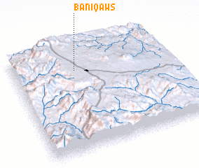 Places with similar names to Banī Qaws, Yemen ::
Disclaimer :: Information on this page comes without warranty of any kind |
||
|
Where is Banī Qaws? Elevation and coordinates ::
Latitude (lat): 14°47'15"N Longitude (lon): 44°24'15"E
Elevation (approx.): 2438m (map arrows pan, magnifying glasses zoom) |
||
|
Visiting Banī Qaws? Hotel/Accommodation ::
Book a hotel in Banī Qaws Travel Guide ::
Buy a travel guide for Yemen rental cars ::
car rental offers GPS waypoint ::
download a GPX waypoint (PoI) of Banī Qaws for your GPS receiver
|
||