|
search place name
|
||
Bayt al Ja‘wirī (Yemen)Bayt al Ja‘wirī is a town in Yemen. An overview map of the region around Bayt al Ja‘wirī is displayed below.
regional and 3d topo map of Bayt al Ja‘wirī, Yemen ::
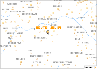
Nearby towns ::
Maḩall Maḑḩ (1.4km east) //
Dafa (2.0km north west) //
Madārī (2.4km north east) //
Maḩall al ‘Umayrī (2.7km north) //
Maḩall Subu‘ (3.1km south east) //
Mati‘ (3.0km east) //
Dhī Şabil (3.3km north east) //
Ta‘izz al Manār (3.5km west) //
Maḩall al Walī (3.7km south west) //
Sūq al Aḩad (4.0km north) //
Az̧ Z̧āli‘ (4.6km north east) //
Maḩall Jabal Qaraḑ (4.8km north) //
Nik Delabiat (5.1km west) //
Aş Şāliḩ (6.8km north) //
Sūq al Ithnayn (7.0km north) //
Al Ḩaddah (7.7km north) //
Ḩabīrah (8.2km south) //
Bayt Suqal (8.5km north) //
Bayt al Jamarah (8.9km north west) //
Maḑarah (9.0km north west) //
Sūq ath Thuluth (9.7km north west) //
‘Umar (9.8km south west) //
Ḩijjān (10.5km north east) //
[all distances 'as the bird flies' and approximate]  Places with similar names to Bayt al Ja‘wirī, Yemen :: Disclaimer :: Information on this page comes without warranty of any kind |
||
|
Where is Bayt al Ja‘wirī? Elevation and coordinates ::
Latitude (lat): 14°36'20"N Longitude (lon): 44°3'51"E
Elevation (approx.): 1658m (map arrows pan, magnifying glasses zoom) |
||
|
Visiting Bayt al Ja‘wirī? Hotel/Accommodation ::
Book a hotel in Bayt al Ja‘wirī Travel Guide ::
Buy a travel guide for Yemen rental cars ::
car rental offers GPS waypoint ::
download a GPX waypoint (PoI) of Bayt al Ja‘wirī for your GPS receiver
|
||