|
search place name
|
||
Ghūlah Dhayfān (Yemen)Ghūlah Dhayfān is a town in Yemen. An overview map of the region around Ghūlah Dhayfān is displayed below.
regional and 3d topo map of Ghūlah Dhayfān, Yemen ::

Ghūlah Dhayfān airports ::
The nearest airport is GIZ - Gizan King Abdullah Bin Abdulaziz, located 203.8 km north west of Ghūlah Dhayfān.
Other airports nearby include EAM - Nejran (209.8 km north), Nearby towns ::
Bayt al Biḩār (2.3km west) //
Nā‘aţ (3.0km east) //
‘Araqah (3.2km east) //
Dhīfān (3.9km south west) //
Bā‘aḑan (4.4km north) //
Wa‘lā (4.4km north west) //
Bayt ar Rubu‘ī (5.2km south west) //
Sumayr (5.3km south) //
Ḩişn Dayfan (5.3km south) //
‘Ambāq (5.8km west) //
Bayt Katmaşar (6.2km west) //
‘Āshib (6.5km south) //
Bayt Hirāsh (8.8km north) //
Raydah (9.3km north) //
Banī az Zubayr (9.7km south west) //
Al Barār (11.7km north west) //
[all distances 'as the bird flies' and approximate] 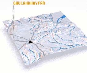 Places with similar names to Ghūlah Dhayfān, Yemen ::
Disclaimer :: Information on this page comes without warranty of any kind |
||
|
Where is Ghūlah Dhayfān? Elevation and coordinates ::
Latitude (lat): 15°44'45"N Longitude (lon): 44°4'15"E
Elevation (approx.): 2450m (map arrows pan, magnifying glasses zoom) |
||
|
Visiting Ghūlah Dhayfān? Hotel/Accommodation ::
Book a hotel in Ghūlah Dhayfān Travel Guide ::
Buy a travel guide for Yemen rental cars ::
car rental offers GPS waypoint ::
download a GPX waypoint (PoI) of Ghūlah Dhayfān for your GPS receiver
|
||