|
search place name
|
||
Īdāt Shams (‘Adan, Yemen)Īdāt Shams is a town in the ‘Adan region of Yemen. An overview map of the region around Īdāt Shams is displayed below.
regional and 3d topo map of Īdāt Shams, Yemen ::

Nearby towns ::
Al Maḩḑarah (1.8km west) //
As Sufāl (2.6km north east) //
‘Arshān (2.6km north west) //
Al Kawrah (3.6km west) //
Miḩlālah (4.1km north west) //
Al Ḩijil (4.0km north west) //
Yashbum (4.0km north west) //
Shi‘b Madū (5.2km north east) //
As Sufāl (5.2km north west) //
Qawlah (5.7km west) //
Al Malaḩah (5.7km west) //
Hiljish (5.8km north east) //
Al Jarw (6.5km south west) //
Haljish (6.6km north east) //
Şāfī (7.2km east) //
Malīlah (7.4km west) //
Īdāt Shams (7.7km north west) //
Ribāţ Banī Shaqqā‘ (8.1km north east) //
Al Marjūm (8.2km south west) //
[all distances 'as the bird flies' and approximate] 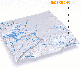 Places with similar names to Īdāt Shams, Yemen ::
// Īdāt Shams (YE)
Disclaimer :: Information on this page comes without warranty of any kind |
||
|
Where is Īdāt Shams? Elevation and coordinates ::
Latitude (lat): 14°18'0"N Longitude (lon): 46°58'0"E
Elevation (approx.): 1449m (map arrows pan, magnifying glasses zoom) |
||
|
Visiting Īdāt Shams? Hotel/Accommodation ::
Book a hotel in Īdāt Shams Travel Guide ::
Buy a travel guide for Yemen rental cars ::
car rental offers GPS waypoint ::
download a GPX waypoint (PoI) of Īdāt Shams for your GPS receiver
|
||