|
search place name
|
||
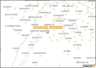
Khums al Manbar (Ta‘izz, Yemen)Khums al Manbar is a town in the Ta‘izz region of Yemen. An overview map of the region around Khums al Manbar is displayed below.
regional and 3d topo map of Khums al Manbar, Yemen ::
Nearby towns ::
Karragu (1.4km south east) //
Wādī al Jisr (2.2km east) //
Ḩuwaysīyah (2.3km north) //
Akhamilla (2.5km north) //
Al Ḩujar (2.8km south east) //
Hawb al Waqī‘ (2.8km north east) //
Qaryat al Manakh (2.9km north west) //
Qaryat al Ḩaşīb (3.7km west) //
Ḩarāz (4.2km south east) //
Al Juraybah (4.7km north west) //
Al Mujayrī (4.7km south west) //
Al Khalfah (5.1km east) //
Maḩşan (5.4km north west) //
Al Habān (5.6km east) //
Raḩābah (5.7km south west) //
Al Quţayn (6.0km north) //
Ḩumarah (6.2km north east) //
Al Jirbayn (6.3km east) //
Al Hajrah (6.5km east) //
Barḩ al Ḩarzah (7.2km north west) //
Wādī Bahsūs (7.4km north) //
Aş Şāfīyah (7.3km south west) //
Al Hassana (7.5km north east) //
Ḩajdah (7.9km north east) //
Ar Rub‘ (8.1km south west) //
Aş Şarāhim (8.3km east) //
Adīnah (8.5km east) //
Al Qub‘ (8.6km north east) //
Bāhitah (8.6km west) //
[all distances 'as the bird flies' and approximate]  Places with similar names to Khums al Manbar, Yemen :: Disclaimer :: Information on this page comes without warranty of any kind |
||
|
Where is Khums al Manbar? Elevation and coordinates ::
Latitude (lat): 13°31'40"N Longitude (lon): 43°46'41"E
Elevation (approx.): 728m (map arrows pan, magnifying glasses zoom) |
||
|
Visiting Khums al Manbar? Hotel/Accommodation ::
Book a hotel in Khums al Manbar Travel Guide ::
Buy a travel guide for Yemen rental cars ::
car rental offers GPS waypoint ::
download a GPX waypoint (PoI) of Khums al Manbar for your GPS receiver
|
||