|
search place name
|
||
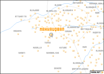
Maḩwá ‘Uqbān (Al Ḩudaydah, Yemen)Maḩwá ‘Uqbān is a town in the Al Ḩudaydah region of Yemen. An overview map of the region around Maḩwá ‘Uqbān is displayed below.
regional and 3d topo map of Maḩwá ‘Uqbān, Yemen ::
Nearby towns ::
Ash Shubayţāʼ (0.8km west) //
Ash Shurayj (1.1km west) //
Al Mukhayrīyān (1.6km east) //
Raqq Suflá (1.9km south west) //
Wādī Bīrah (2.3km west) //
Bayt al Futt (2.5km north) //
Ţurqūh (3.0km north) //
Kudayf (3.1km north) //
At Turbah (3.2km east) //
Terko (3.4km south west) //
Sharīj Bīrah (3.7km north west) //
Wādī ‘Ayn (4.1km north west) //
Janb al ‘Ayr (4.0km east) //
Qaryat as Sādah (4.2km east) //
Al Maqāţīn (4.8km north west) //
Qaryat al Mazājīj (4.9km north east) //
Maḩwá an Nāz̧ir (5.1km north east) //
Al Mahdalī (5.1km north west) //
Māti‘ (5.1km north east) //
Misqāyah (5.2km north) //
Bilād al Musāwāh (5.1km east) //
Maḩwá ‘Umārī (5.3km north) //
Ḩājjī ash Shamīrī (5.6km north) //
Umm Qubayr (5.7km south east) //
Al Masāḩīb (5.9km east) //
Bayt Quraybah (5.9km east) //
Maḩwá al ‘Ajībah (6.1km north) //
Al Ḩillah (6.1km north) //
Al Ḩawḑ (6.3km north) //
[all distances 'as the bird flies' and approximate]  Places with similar names to Maḩwá ‘Uqbān, Yemen :: Disclaimer :: Information on this page comes without warranty of any kind |
||
|
Where is Maḩwá ‘Uqbān? Elevation and coordinates ::
Latitude (lat): 14°7'42"N Longitude (lon): 43°19'46"E
Elevation (approx.): 109m (map arrows pan, magnifying glasses zoom) |
||
|
Visiting Maḩwá ‘Uqbān? Hotel/Accommodation ::
Book a hotel in Maḩwá ‘Uqbān Travel Guide ::
Buy a travel guide for Yemen rental cars ::
car rental offers GPS waypoint ::
download a GPX waypoint (PoI) of Maḩwá ‘Uqbān for your GPS receiver
|
||