|
search place name
|
||
Nebel (‘Adan, Yemen)Nebel is a town in the ‘Adan region of Yemen. An overview map of the region around Nebel is displayed below.
regional and 3d topo map of Nebel, Yemen ::

Nearby towns ::
Az Zīrah (1.9km north) //
Bayt al Ḩujarīyah (1.8km west) //
Al Hif (1.8km east) //
Turmānah (2.6km north west) //
Ad Dūr (2.6km north west) //
Ahilet (2.6km north east) //
Kodina (3.7km north) //
Al Hokamin (3.7km south) //
Malḩamah (4.1km north west) //
Nazere (4.1km north east) //
Bayt al Kaban (4.1km south west) //
Soedid (4.0km north east) //
Adh Dhime (4.1km south east) //
Usni al Hadad (4.0km south east) //
Al Ḩamādī (4.9km east) //
Ash Sharaf (5.7km west) //
Qamālah (5.8km south) //
Sūq al Khamīs (5.7km east) //
Dermie (5.7km east) //
Al Milala (6.6km south west) //
Rakbān (6.5km north east) //
Dhara (6.6km north east) //
Al Makhādir (7.3km north west) //
Jeboib (7.2km east) //
Dār ‘Ammārī (7.4km west) //
Al Jubayb (7.4km east) //
Maḩşan (7.7km south west) //
Manzil Roye (9.2km south west) //
[all distances 'as the bird flies' and approximate] 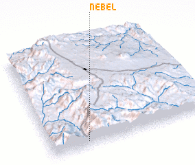 Places with similar names to Nebel, Yemen ::
Disclaimer :: Information on this page comes without warranty of any kind |
||
|
Where is Nebel? Elevation and coordinates ::
Latitude (lat): 14°4'0"N Longitude (lon): 44°14'0"E
Elevation (approx.): 2457m (map arrows pan, magnifying glasses zoom) |
||
|
Visiting Nebel? Hotel/Accommodation ::
Book a hotel in Nebel Travel Guide ::
Buy a travel guide for Yemen rental cars ::
car rental offers GPS waypoint ::
download a GPX waypoint (PoI) of Nebel for your GPS receiver
|
||