|
search place name
|
||
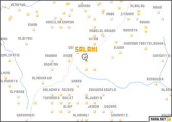
Salāmī (‘Adan, Yemen)Salāmī is a town in the ‘Adan region of Yemen. An overview map of the region around Salāmī is displayed below.
regional and 3d topo map of Salāmī, Yemen ::
Nearby towns ::
Arad (0.0km north) //
Jirnir (1.9km north) //
Usni Rekab (1.9km south) //
Usni Yesir (2.6km north west) //
Bayt Kerdi (2.6km south east) //
Rikab (3.6km west) //
Bayt ‘Izz ad Dīn (3.6km west) //
Kitāb (4.1km north east) //
Dakhlat al Masālimih (5.6km east) //
Dhara (5.8km south) //
Meshen (5.8km north) //
Nobel al Haidan (6.6km north east) //
Al Manzil (6.8km north east) //
Nawbat Ḩajar (7.2km west) //
Nawbah (7.2km west) //
Rakbān (7.4km south) //
Aţ Ţālūqah ad Dakhlah (7.6km north) //
Aḑ Ḑay‘ah (7.4km west) //
Ejuan (7.4km east) //
Rubāţ al Qal‘ah (7.5km north east) //
Al Majātah (8.2km north west) //
Nazere (8.2km south west) //
Rakwān as Suflá (8.2km south east) //
Manzil Nasmārah (9.2km north west) //
Kodina (9.2km south west) //
Ma‘bar (10.3km north west) //
Malḩamah (10.3km south west) //
[all distances 'as the bird flies' and approximate]  Places with similar names to Salāmī, Yemen ::
Disclaimer :: Information on this page comes without warranty of any kind |
||
|
Where is Salāmī? Elevation and coordinates ::
Latitude (lat): 14°10'0"N Longitude (lon): 44°17'0"E
Elevation (approx.): 2926m (map arrows pan, magnifying glasses zoom) |
||
|
Visiting Salāmī? Hotel/Accommodation ::
Book a hotel in Salāmī Travel Guide ::
Buy a travel guide for Yemen rental cars ::
car rental offers GPS waypoint ::
download a GPX waypoint (PoI) of Salāmī for your GPS receiver
|
||