|
search place name
|
||
Suḩayl (‘Adan, Yemen)Suḩayl is a town in the ‘Adan region of Yemen. An overview map of the region around Suḩayl is displayed below.
regional and 3d topo map of Suḩayl, Yemen ::
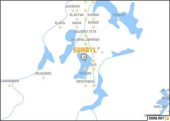
Nearby towns ::
Ad Daymah (1.8km east) //
Akramah (1.9km south) //
Bayt al Faqīr (2.6km north east) //
Tamrah (2.6km north east) //
Laqrah (2.6km north east) //
‘Ayn (2.6km south east) //
Ḩajar al Jaḩḩāsh (3.7km north) //
Samnah (3.7km south) //
Nawwār (3.7km south) //
Biʼr Juwaynah (4.0km north east) //
Hassim Bedi (5.6km south) //
Ḩajar aţ Ţāʼţāʼ (5.6km north) //
Darb al ‘Amr (5.8km south) //
Shaqīr (7.6km north) //
Ḩarīb (7.6km north) //
Darb al Ma‘ārif (7.6km north) //
Al ‘Arḑ (9.2km north west) //
[all distances 'as the bird flies' and approximate] 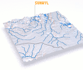 Places with similar names to Suḩayl, Yemen ::
Disclaimer :: Information on this page comes without warranty of any kind |
||
|
Where is Suḩayl? Elevation and coordinates ::
Latitude (lat): 14°52'0"N Longitude (lon): 45°31'0"E
Elevation (approx.): 1194m (map arrows pan, magnifying glasses zoom) |
||
|
Visiting Suḩayl? Hotel/Accommodation ::
Book a hotel in Suḩayl Travel Guide ::
Buy a travel guide for Yemen rental cars ::
car rental offers GPS waypoint ::
download a GPX waypoint (PoI) of Suḩayl for your GPS receiver
|
||