|
search place name
|
||
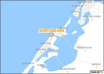
Shandaghah (Dubayy, United Arab Emirates)Shandaghah is a town in the Dubayy region of United Arab Emirates. An overview map of the region around Shandaghah is displayed below.
regional and 3d topo map of Shandaghah, United Arab Emirates ::
nearby GPS traces from timatio ::
Shandaghah airports ::
The nearest airport is DXB - Dubai Intl, located 8.2 km east of Shandaghah.
Other airports nearby include SHJ - Sharjah Intl (24.8 km east), RKT - Ras Al Khaimah Intl (76.8 km north east), FJR - Fujeirah Fujairah Intl (106.1 km east), AUH - Abu Dhabi Intl (111.5 km south west), Nearby towns ::
Dubayy (0.8km south west) //
Barr Dubayy (1.2km north east) //
Dayrah (3.2km north east) //
Al Barāḩah (3.5km east) //
As Saţwah (3.8km south west) //
Abū Hayl (4.5km north east) //
Za‘bīl (5.4km south) //
Jumayrah (6.5km south west) //
Al Khān (11.2km north east) //
[all distances 'as the bird flies' and approximate] 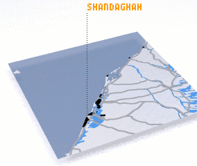 Places with similar names to Shandaghah, United Arab Emirates ::
Disclaimer :: Information on this page comes without warranty of any kind |
||
|
Where is Shandaghah? Elevation and coordinates ::
Latitude (lat): 25°15'30"N Longitude (lon): 55°17'0"E
Elevation (approx.): 5m (map arrows pan, magnifying glasses zoom) |
||
|
Visiting Shandaghah? Hotel/Accommodation ::
Book a hotel in Shandaghah Travel Guide ::
rental cars ::
car rental offers GPS waypoint ::
download a GPX waypoint (PoI) of Shandaghah for your GPS receiver
|
||