|
search place name
|
||
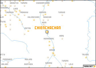
Chien-ch'a-chan (T'ai-wan, Taiwan)Chien-ch'a-chan is a town in the T'ai-wan region of Taiwan. An overview map of the region around Chien-ch'a-chan is displayed below.
regional and 3d topo map of Chien-ch'a-chan, Taiwan ::
Chien-ch'a-chan airports ::
The nearest airport is CYI - Chiayi, located 53.4 km south west of Chien-ch'a-chan.
Other airports nearby include HUN - Hualien (86.1 km north east), TTT - Fengnin (103.8 km south), TNN - Tainan (104.2 km south west), PIF - Pingtung South (117.7 km south), Nearby towns ::
Hsin-hsiang (3.0km south) //
Hsin-i (3.6km north) //
Ai-kuo (4.1km north west) //
Hsin-i (4.4km south) //
San-shih-chia (5.6km north) //
Shih-chia (5.6km north) //
Chiu-mei (5.8km south) //
Ha-pu (5.4km east) //
T'ien-tzu-ti (5.8km north) //
Shang-an-ts'un (5.8km north) //
Chün-hsi-k'ou (5.8km north) //
An-k'eng (7.6km north) //
Ho-she (7.6km south) //
Chün-k'eng (7.8km north) //
Hsi-t'ou (7.2km west) //
Ku-ling-chiao (7.5km north west) //
Wang-mei (7.9km south) //
T'ung-fu (8.6km south) //
T'ung-ko (9.0km north east) //
[all distances 'as the bird flies' and approximate] 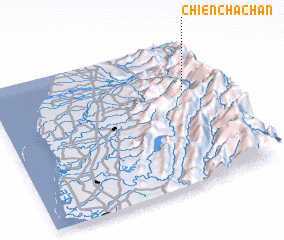 Places with similar names to Chien-ch'a-chan, Taiwan :: Disclaimer :: Information on this page comes without warranty of any kind |
||
|
Where is Chien-ch'a-chan? Elevation and coordinates ::
Latitude (lat): 23°40'0"N Longitude (lon): 120°52'0"E
Elevation (approx.): 551m (map arrows pan, magnifying glasses zoom) |
||
|
Visiting Chien-ch'a-chan? Hotel/Accommodation ::
Book a hotel in Chien-ch'a-chan Travel Guide ::
Buy a travel guide for Taiwan rental cars ::
car rental offers GPS waypoint ::
download a GPX waypoint (PoI) of Chien-ch'a-chan for your GPS receiver
|
||