|
search place name
|
||
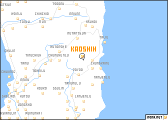
Kao-shih (T'ai-wan, Taiwan)Kao-shih is a town in the T'ai-wan region of Taiwan. An overview map of the region around Kao-shih is displayed below.
regional and 3d topo map of Kao-shih, Taiwan ::
Kao-shih airports ::
The nearest airport is KHH - Kaohsiung Intl, located 71.2 km north west of Kao-shih.
Other airports nearby include KYD - Lanyu (71.5 km east), PIF - Pingtung South (71.8 km north west), TTT - Fengnin (73.6 km north), GNI - Green Island Lyudao (87.2 km north east), Nearby towns ::
Kang-tzu (1.7km east) //
Chiu-cha (2.5km south east) //
Pa-yao (3.5km south) //
Chung-kang (3.9km south east) //
Mu-tan-ts'un (5.1km north) //
Pa-yao-lu (5.1km south west) //
Chung-wen-lu (5.2km west) //
Mu-tan-she (5.5km west) //
Nan-shan-lu (5.8km south) //
Ta-liu (5.9km north east) //
Nan-jen-lu (6.3km south east) //
Ta-kung-lu (6.7km south) //
Ch'ieh-chih-lu (6.9km west) //
Hsü-hai (7.6km north) //
Tung-yüan (7.8km north) //
Wan-te-lu (8.3km south) //
Mu-tan (8.1km west) //
Ssu-lin (9.0km south west) //
Hsiao-lu (9.0km south west) //
[all distances 'as the bird flies' and approximate] 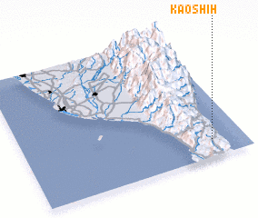 Places with similar names to Kao-shih, Taiwan ::
Disclaimer :: Information on this page comes without warranty of any kind |
||
|
Where is Kao-shih? Elevation and coordinates ::
Latitude (lat): 22°8'0"N Longitude (lon): 120°51'0"E
Elevation (approx.): 294m (map arrows pan, magnifying glasses zoom) |
||
|
Visiting Kao-shih? Hotel/Accommodation ::
Book a hotel in Kao-shih Travel Guide ::
Buy a travel guide for Taiwan rental cars ::
car rental offers GPS waypoint ::
download a GPX waypoint (PoI) of Kao-shih for your GPS receiver
|
||