|
search place name
|
||
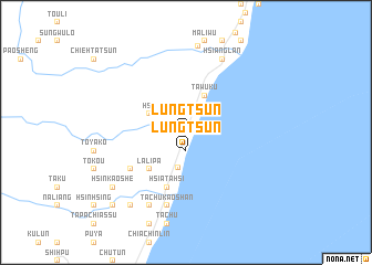
Lung-ts'un (T'ai-wan, Taiwan)Lung-ts'un is a town in the T'ai-wan region of Taiwan. An overview map of the region around Lung-ts'un is displayed below.
regional and 3d topo map of Lung-ts'un, Taiwan ::
Lung-ts'un airports ::
The nearest airport is TTT - Fengnin, located 30.7 km north east of Lung-ts'un.
Other airports nearby include PIF - Pingtung South (53.1 km west), GNI - Green Island Lyudao (55.9 km east), KHH - Kaohsiung Intl (62.1 km west), KYD - Lanyu (80.8 km south east), Nearby towns ::
Shang-to-liang (0.0km north) //
Hsia-to-liang (1.9km north) //
Pin-mao-ts'un (1.9km north) //
Chin-lun (1.9km north) //
Lung-ts'un (1.9km south) //
Hsiao-chin-lun (2.5km north west) //
Shang-ta-hsi (3.6km south) //
Li-ch'iu (3.9km north west) //
Ta-wu-k'u (4.1km north east) //
La-li-pa (5.0km south west) //
Hsia-ta-hsi (5.8km south) //
T'ai-fan (6.3km south west) //
Ta-chu-kao-shan (7.6km south) //
Chiu-hsiang-lan (8.2km north east) //
Hsiang-lan (8.2km north east) //
Ai-p'u (8.2km south west) //
Chia-lan (8.7km north) //
Chin-feng (8.7km north) //
Chia-k'uo-pu-ts'un (9.0km south west) //
Hsin-kao-she (8.8km south west) //
Shang-fan (10.1km south west) //
[all distances 'as the bird flies' and approximate] 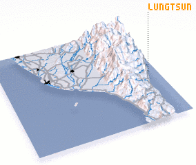 Places with similar names to Lung-ts'un, Taiwan ::
// Lung-ts'un (TW)
// Lung-tzu-nei (TW)
Disclaimer :: Information on this page comes without warranty of any kind |
||
|
Where is Lung-ts'un? Elevation and coordinates ::
Latitude (lat): 22°31'0"N Longitude (lon): 120°57'0"E
Elevation (approx.): 445m (map arrows pan, magnifying glasses zoom) |
||
|
Visiting Lung-ts'un? Hotel/Accommodation ::
Book a hotel in Lung-ts'un Travel Guide ::
Buy a travel guide for Taiwan rental cars ::
car rental offers GPS waypoint ::
download a GPX waypoint (PoI) of Lung-ts'un for your GPS receiver
|
||