|
search place name
|
||
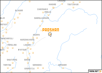
Pao-shan (T'ai-wan, Taiwan)Pao-shan is a town in the T'ai-wan region of Taiwan. An overview map of the region around Pao-shan is displayed below.
regional and 3d topo map of Pao-shan, Taiwan ::
Pao-shan airports ::
The nearest airport is PIF - Pingtung South, located 47.8 km south west of Pao-shan.
Other airports nearby include TTT - Fengnin (50.9 km south east), TNN - Tainan (52.6 km west), CYI - Chiayi (57.1 km north west), KHH - Kaohsiung Intl (62.9 km south west), Nearby towns ::
Sen-t'ao (2.5km north east) //
Hsin-k'ai (3.9km north west) //
Hsin-fa (4.8km west) //
Lao-nung (5.4km north west) //
Shang-lao-nung (6.4km north west) //
Shih-o-t'ou (6.2km west) //
Chiu-t'an (6.6km west) //
Pao-lai (8.0km north) //
T'u-lung (8.3km south west) //
Hung-shui-k'eng (8.2km west) //
Mei-chuang (8.6km south west) //
Chien-shan (9.2km north) //
Liu-kuei (8.9km south west) //
T'u-lung-wan (8.9km south west) //
Chiu-chuang (9.6km south west) //
Fu-hsing (11.1km south west) //
[all distances 'as the bird flies' and approximate] 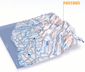 Places with similar names to Pao-shan, Taiwan ::
Disclaimer :: Information on this page comes without warranty of any kind |
||
|
Where is Pao-shan? Elevation and coordinates ::
Latitude (lat): 23°2'14"N Longitude (lon): 120°42'36"E
Elevation (approx.): 1015m (map arrows pan, magnifying glasses zoom) |
||
|
Visiting Pao-shan? Hotel/Accommodation ::
Book a hotel in Pao-shan Travel Guide ::
Buy a travel guide for Taiwan rental cars ::
car rental offers GPS waypoint ::
download a GPX waypoint (PoI) of Pao-shan for your GPS receiver
|
||