|
search place name
|
||
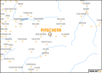
P'ing-che-na (T'ai-wan, Taiwan)P'ing-che-na is a town in the T'ai-wan region of Taiwan. An overview map of the region around P'ing-che-na is displayed below.
regional and 3d topo map of P'ing-che-na, Taiwan ::
P'ing-che-na airports ::
The nearest airport is CYI - Chiayi, located 38.7 km west of P'ing-che-na.
Other airports nearby include TNN - Tainan (85.0 km south west), TTT - Fengnin (91.1 km south), PIF - Pingtung South (98.6 km south), HUN - Hualien (103.3 km north east), Nearby towns ::
Erh-wan-p'ing (1.7km east) //
Lai-chi-she (3.0km north west) //
Shih-tzu-lu (3.2km south west) //
I-mu-chih-she (3.4km west) //
Shen-mu (4.4km east) //
Mien-yüeh (5.0km north east) //
A-li-shan (4.9km east) //
To-lo-yen (5.4km west) //
Fu-yeh (5.8km south) //
Hui-lung (6.5km north east) //
Ha-li-wei (6.3km north west) //
Feng-shan (7.0km north west) //
Wu-feng (7.2km south) //
Ta-te (8.2km south west) //
Le-yeh (8.6km south west) //
Lu-ch'ü-tzu (10.1km north west) //
Ts'ao-ling (11.0km north west) //
[all distances 'as the bird flies' and approximate]  Places with similar names to P'ing-che-na, Taiwan ::
// Pangusión (ES)
// Pangchen (IN)
// Pankshin (NG)
// Pang-ch'on (KR)
// Pangch'on (KR)
// Pong-ch'on (KR)
// Pong-ch'on (KR)
// Pongch'on (KR)
// Pongch'on (KR)
// Pongch'on (KR)
Disclaimer :: Information on this page comes without warranty of any kind |
||
|
Where is P'ing-che-na? Elevation and coordinates ::
Latitude (lat): 23°31'0"N Longitude (lon): 120°46'0"E
Elevation (approx.): 1264m (map arrows pan, magnifying glasses zoom) |
||
|
Visiting P'ing-che-na? Hotel/Accommodation ::
Book a hotel in P'ing-che-na Travel Guide ::
Buy a travel guide for Taiwan rental cars ::
car rental offers GPS waypoint ::
download a GPX waypoint (PoI) of P'ing-che-na for your GPS receiver
|
||