|
search place name
|
||
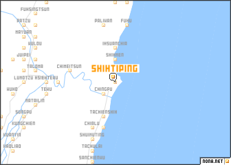
Shih-t'i-p'ing (T'ai-wan, Taiwan)Shih-t'i-p'ing is a town in the T'ai-wan region of Taiwan. An overview map of the region around Shih-t'i-p'ing is displayed below.
regional and 3d topo map of Shih-t'i-p'ing, Taiwan ::
Shih-t'i-p'ing airports ::
The nearest airport is HUN - Hualien, located 61.0 km north of Shih-t'i-p'ing.
Other airports nearby include GNI - Green Island Lyudao (89.7 km south), TTT - Fengnin (90.4 km south west), CYI - Chiayi (113.1 km west), PIF - Pingtung South (139.2 km south west), Nearby towns ::
Kang-k'ou-ts'un (0.0km north) //
Shih-t'i-wan (1.9km north) //
Ching-pu (2.5km south west) //
Ta-kang-k'ou (2.5km south west) //
Shih-men (3.7km north) //
I-hsüan-chia (5.6km north) //
Ta-chien-shih (5.8km south) //
Chang-yüan (7.6km south) //
Ch'i-mei-ts'un (7.0km west) //
Chia-lu (8.2km south west) //
[all distances 'as the bird flies' and approximate]  Places with similar names to Shih-t'i-p'ing, Taiwan ::
// Shatouping (CN)
// Shih-t'ou-p'ing (TW)
// Shui-ti-p'ing (TW)
// Chutouping (CN)
// Shataping (CN)
Disclaimer :: Information on this page comes without warranty of any kind |
||
|
Where is Shih-t'i-p'ing? Elevation and coordinates ::
Latitude (lat): 23°29'0"N Longitude (lon): 121°30'0"E
Elevation (approx.): 126m (map arrows pan, magnifying glasses zoom) |
||
|
Visiting Shih-t'i-p'ing? Hotel/Accommodation ::
Book a hotel in Shih-t'i-p'ing Travel Guide ::
Buy a travel guide for Taiwan rental cars ::
car rental offers GPS waypoint ::
download a GPX waypoint (PoI) of Shih-t'i-p'ing for your GPS receiver
|
||