|
search place name
|
||
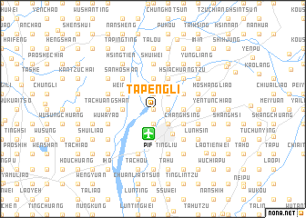
Ta-p'eng-li (T'ai-wan, Taiwan)Ta-p'eng-li is a town in the T'ai-wan region of Taiwan. An overview map of the region around Ta-p'eng-li is displayed below.
regional and 3d topo map of Ta-p'eng-li, Taiwan ::
Ta-p'eng-li airports ::
The nearest airport is PIF - Pingtung South, located 3.1 km south of Ta-p'eng-li.
Other airports nearby include KHH - Kaohsiung Intl (18.1 km south west), TNN - Tainan (38.5 km north west), TTT - Fengnin (65.5 km east), CYI - Chiayi (84.7 km north), Nearby towns ::
Ch'ung-lan (0.0km north) //
Kuang-hsing (1.7km east) //
Ho-hsing (1.7km east) //
T'an-ch'ien (1.9km south) //
Ch'ung-lan (1.9km south) //
Yü-shui (1.9km north) //
Pei-shih (2.5km south east) //
Hua-shan-li (2.5km south east) //
Jih-ch'u (2.5km north east) //
Hai-feng (3.4km east) //
Chung-hsin (3.4km east) //
Ch'ang-an-li (3.7km south) //
An-chen-li (3.7km south) //
K'an-tzu-ting (3.7km north) //
Ku-shan (3.4km west) //
Ta-chuang (3.4km west) //
P'ing-tung (3.8km south east) //
Ch'e-ning (4.1km north east) //
Chiu-ju (4.1km north east) //
Lin-tzu-t'ou (4.1km north east) //
Chiu-kuei-ts'un (4.1km north east) //
Ch'ang-hsing (3.9km south east) //
Yü-ch'üan-ts'un (3.9km north east) //
Wei-nei (3.9km north west) //
San-chiao-liao (3.9km north west) //
Ta-k'eng (3.9km north west) //
Hsing-hua-pu (3.9km north west) //
Chou-tzu (3.9km north west) //
Shui-yüan-ti (5.0km south east) //
[all distances 'as the bird flies' and approximate] 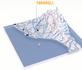 Places with similar names to Ta-p'eng-li, Taiwan ::
Disclaimer :: Information on this page comes without warranty of any kind |
||
|
Where is Ta-p'eng-li? Elevation and coordinates ::
Latitude (lat): 22°42'0"N Longitude (lon): 120°28'0"E
Elevation (approx.): 20m (map arrows pan, magnifying glasses zoom) |
||
|
Visiting Ta-p'eng-li? Hotel/Accommodation ::
Book a hotel in Ta-p'eng-li Travel Guide ::
Buy a travel guide for Taiwan rental cars ::
car rental offers GPS waypoint ::
download a GPX waypoint (PoI) of Ta-p'eng-li for your GPS receiver
|
||