|
search place name
|
||
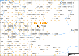
Ta-p'o-t'ang (T'ai-wan, Taiwan)Ta-p'o-t'ang is a town in the T'ai-wan region of Taiwan. An overview map of the region around Ta-p'o-t'ang is displayed below.
regional and 3d topo map of Ta-p'o-t'ang, Taiwan ::
Ta-p'o-t'ang airports ::
The nearest airport is TPE - Taipei Chiang Kai Shek Intl, located 72.3 km north east of Ta-p'o-t'ang.
Other airports nearby include HUN - Hualien (90.0 km south east), TSA - Taipei Sungshan (91.3 km north east), CYI - Chiayi (126.0 km south west), MZG - Makung Magong (165.5 km south west), Nearby towns ::
Pa-kua (1.7km east) //
Yen-shui-k'eng (1.9km south) //
Hsiang-yüan-wo (1.7km west) //
Ho-hsing (2.2km north east) //
Shih-chiu-fen (2.5km north east) //
Pa-chiao (2.5km south west) //
An-ying (2.5km north west) //
Shih-i-fen-ssu (3.7km south) //
T'ai-hsing-wo (3.7km south) //
Fu-hsing (3.7km north) //
Chung-hsing (3.7km north) //
Hsin-shih-men (3.4km west) //
Hsin-tien (4.1km north east) //
Shih-chiu-fen (4.1km north east) //
Hsia-pan-t'ien-liao (4.1km south east) //
Ta-tung-shih (4.1km north east) //
Sha-wu-lu (3.8km south east) //
Pei-ho (4.1km north west) //
Shih-t'ou-t'u (4.1km north west) //
Pei-chuang (4.1km south west) //
Nan-chuang (4.1km south west) //
Chu-mu-ts'un (4.1km south west) //
Ta-wo (4.1km north west) //
Tung-k'eng (3.8km south west) //
Hsin-kung-kuan (3.8km north west) //
Hsin-pei-liao (3.8km south west) //
Pan-lu-liao (3.8km north west) //
Shih-t'an (5.0km north east) //
Hu-shan (5.0km south east) //
[all distances 'as the bird flies' and approximate] 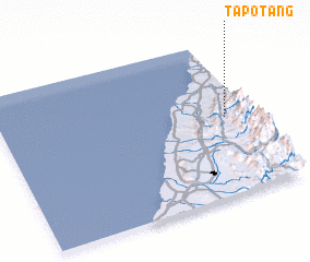 Places with similar names to Ta-p'o-t'ang, Taiwan ::
Disclaimer :: Information on this page comes without warranty of any kind |
||
|
Where is Ta-p'o-t'ang? Elevation and coordinates ::
Latitude (lat): 24°30'0"N Longitude (lon): 120°54'0"E
Elevation (approx.): 337m (map arrows pan, magnifying glasses zoom) |
||
|
Visiting Ta-p'o-t'ang? Hotel/Accommodation ::
Book a hotel in Ta-p'o-t'ang Travel Guide ::
Buy a travel guide for Taiwan rental cars ::
car rental offers GPS waypoint ::
download a GPX waypoint (PoI) of Ta-p'o-t'ang for your GPS receiver
|
||