|
search place name
|
||
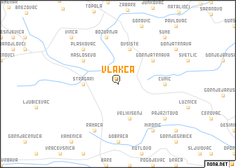
Vlakča (Srbija, Serbia and Montenegro)Vlakča is a town in the Srbija region of Serbia and Montenegro. An overview map of the region around Vlakča is displayed below.
regional and 3d topo map of Vlakča, Serbia and Montenegro ::
Vlakča airports ::
The nearest airport is BEG - Beograd, located 81.0 km north west of Vlakča.
Other airports nearby include INI - Nis (128.6 km south east), PRN - Pristina (177.1 km south), CSB - Caransebes (186.3 km north east), TSR - Timisoara Traian Vuia (190.9 km north), Nearby towns ::
Stragari (4.0km west) //
Mala Vrbica (5.7km south) //
Veliki Šenj (5.7km south) //
Ovsište (5.7km north) //
Gornja Trnava (5.4km north east) //
Masloševo (5.4km north west) //
Čumić (5.3km east) //
Božurnja (7.5km north) //
Plaskovac (6.8km north west) //
Ramaća (7.9km south) //
Mali Šenj (7.7km south east) //
Pajazitovo (7.7km south east) //
Mironić (8.4km south east) //
Šume (9.1km north east) //
Vinča (9.1km north west) //
[all distances 'as the bird flies' and approximate]  Places with similar names to Vlakča, Serbia and Montenegro ::
// Vil'kouku (RU)
// Vilquico (CL)
// Valkkoog (NL)
// Phú Lạc (2) (VN)
// Phú Lạc (2) (VN)
// Phú Lộc (2) (VN)
// Phú Lộc (2) (VN)
// Filikaíika (GR)
Disclaimer :: Information on this page comes without warranty of any kind |
||
|
Where is Vlakča? Elevation and coordinates ::
Latitude (lat): 44°9'0"N Longitude (lon): 20°43'0"E
Elevation (approx.): 346m (map arrows pan, magnifying glasses zoom) |
||
|
Visiting Vlakča? Hotel/Accommodation ::
Book a hotel in Vlakča Travel Guide ::
rental cars ::
car rental offers GPS waypoint ::
download a GPX waypoint (PoI) of Vlakča for your GPS receiver
|
||