|
search place name
|
||
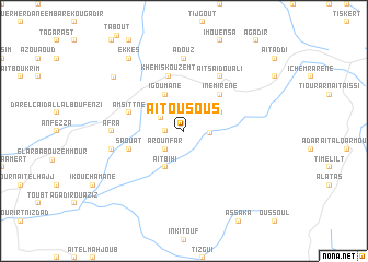
Aït Ou Sous (Essaouira, Morocco)Aït Ou Sous is a town in the Essaouira region of Morocco. An overview map of the region around Aït Ou Sous is displayed below.
regional and 3d topo map of Aït Ou Sous, Morocco ::
Aït Ou Sous airports ::
The nearest airport is AGA - Agadir Inezgane, located 76.5 km south of Aït Ou Sous.
Other airports nearby include RAK - Marrakech Menara (134.7 km north east), Nearby towns ::
Douar Krakra (1.6km west) //
Timsal (1.9km north) //
Arounfar (2.4km south west) //
Taghzout (2.4km north west) //
Agadir nʼAït Ali (2.3km east) //
Oulad Ali (4.0km south west) //
Aït Bihi (4.0km south west) //
Tichouktine (3.7km north east) //
Igoumane (4.0km north west) //
Igrane (4.9km north east) //
Inemirene (4.9km north east) //
Khemis Kouzemt (5.8km north) //
Saouat (5.1km west) //
Fissioulil (5.1km west) //
Amsittne (5.1km west) //
Aït Saïd Ou Ali (6.4km north east) //
Afra (6.4km west) //
Adouz (7.4km north) //
Dirkt (6.6km west) //
Es Sebt Aït Daoud (8.2km north west) //
Ekkes (8.8km north west) //
[all distances 'as the bird flies' and approximate] 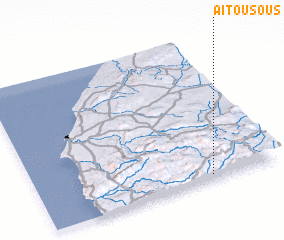 Places with similar names to Aït Ou Sous, Morocco ::
Disclaimer :: Information on this page comes without warranty of any kind |
||
|
Where is Aït Ou Sous? Elevation and coordinates ::
Latitude (lat): 31°2'0"N Longitude (lon): 9°17'0"W
Elevation (approx.): 1190m (map arrows pan, magnifying glasses zoom) |
||
|
Visiting Aït Ou Sous? Hotel/Accommodation ::
Book a hotel in Aït Ou Sous Travel Guide ::
Buy a travel guide for Morocco rental cars ::
car rental offers GPS waypoint ::
download a GPX waypoint (PoI) of Aït Ou Sous for your GPS receiver
|
||